- They couldn’t save their daughters’ lives in the July 4 floods. Now they’re dealing with the grief and the guilt.
- Austin could see heavy rains, possible flooding over the next few days
- Families of campers, counselors who died in Texas Hill County floods sue Camp Mystic
- Small plane bound for Jamaica with hurricane relief supplies crashes in Florida neighborhood
- Ask the Meteorologist: Did a tornado hit Johnston County Saturday night?
'DVD-sized hail' reported in the Texas Panhandle, meteorologist says
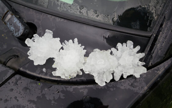
As severe weather season continues its wrath through Texas, one area in particular saw a rare moment for Mother Nature Tuesday afternoon. According to Matthew Cappucci, a meteorologist with MyRadar Weather, reported seeing ‘DVD-sized hail’ in the Texas Panhandle.
The National Weather Service forecast for Tuesday, April 29, indicated that severe thunderstorms were possible in areas of the southeast Texas Panhandle. Guthrie is located near Lubbock. The NWS also said that quarter-sized hail was expected with the storms. However, images shared by Cappucci showed hail sizes exceeding 4 inches. According to the NWS, hail that is DVD-sized can range from 4 to 5 inches in diameter.
“Even after a bit of melting, 4.74 inches. Wow,” he said.
Meteorologist Brandon Sullivan reported a supercell in the area dropped hail, but it wasn’t DVD-sized.
“Didn’t see the DVD size hail but 2” and a tennis ball or two,” Sullivan wrote.
The Texas Panhandle isn’t out of the woods when it come to severe weather. The National Weather Service warns another round of severe weather could plague the area.
“Severe thunderstorms will be possible across much of the central and eastern Texas Panhandle on Wednesday. Hail to around the size of quarters and damaging winds will be the main threat,” the National Weather Service said. “Be prepared for reduced visibility from heavy rain and do not drive through flooded roadways.”