- Raleigh rethinks how to grow as flooding, heat and traffic worsen
- New legislative panels will investigate ‘facts and circumstances’ of deadly Central Texas floods
- Heavy rain floods downtown Whiteville forcing local businesses to deal with damage again
- New legislative panels will investigate “facts and circumstances” of deadly Central Texas floods
- Springfield Middle School fully reopens next week, a year after devastating EF3 tornado
Hurricane Michael is continuing to intensify
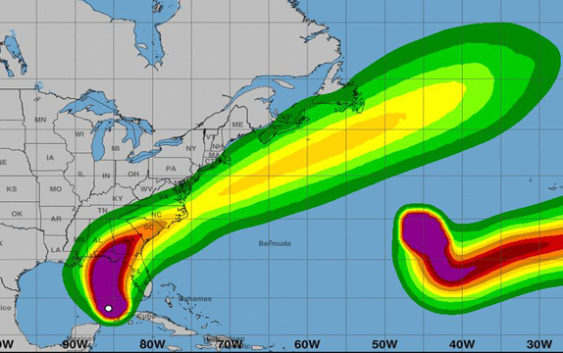
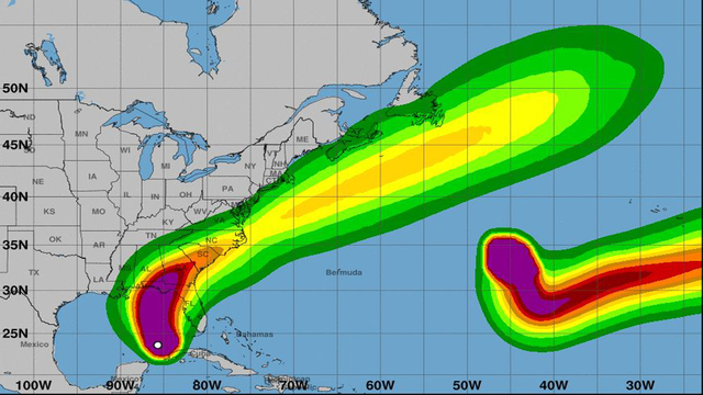 National Hurricane Center, Tropical Storm Force Wind Speed Probabilities
 TALLAHASSEE, Fla. (AP) – Hurricane Michael continues to gain strength as it moves through the southern Gulf of Mexico.
By 5 a.m. Tuesday, Michael’s top sustained winds had risen some to 90 mph (144 kph) as it headed north at 12 mph (19 kph).
The Category 1 storm was centered about 390 miles (627 kilometers) south of Apalachicola and 420 miles (675 kilometers) south of Panama City, Florida. Hurricane-force winds extended outward up to 35 miles (56 kilometers) from the core and tropical-storm-force winds out 175 miles (280 kilometers).
Hurricane-force winds extended outward up to 40 miles (64 kilometers) from the core and tropical-storm-force winds out 195 miles (313.81 kilometers).
LINK: See more models on MyFoxHurricane.com
Forecasters say the center of Michael will continue to move over the southern Gulf of Mexico Tuesday morning. The storm will then move across the eastern Gulf of Mexico later Tuesday into the night.
The center is then expected to move inland over the Florida Panhandle or Florida Big Bend area on Wednesday, and then move northeastward across the southeastern United States Wednesday night and Thursday.
For more information on Hurricane Michael, click here.