- Eric Tulsky comfortable, confident and going for the Stanley Cup in 2nd year as Hurricanes GM
- 5 homes collapse into the surf of the Outer Banks as hurricanes rumble in Atlantic
- As hurricanes pass offshore, more Buxton homes collapse into the sea
- Central Texas floods reveal need to shore up disaster response in unincorporated areas
- Latest: Tropical Storm Imelda will pull away from East Coast, expected to become a hurricane
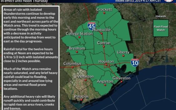
Flash flood watch in effect until noon
-
Southeast Texas is under a flash flood watch until noon on Thursday, Jan. 3, 2019.
Southeast Texas is under a flash flood watch until noon on Thursday, Jan. 3, 2019.
Photo: National Weather Service Houston/Galveston
Southeast Texas is under a flash flood watch until noon on Thursday, Jan. 3, 2019.
Southeast Texas is under a flash flood watch until noon on Thursday, Jan. 3, 2019.
Photo: National Weather Service Houston/Galveston
A flash flood watch will last until noon in southeast Texas, with rain activity expected to dwindle as the day continues.
Flooding is expected until 6:30 a.m. in parts of Montgomery County, northwestern Fort Bend County, Waller County, west central Liberty County and northwestern Harris County, according to the National Weather Service.
The rain and isolated thunderstorms are moving east and northeast, meteorologists said. By noon, 2 inches of rain will have been possible in the areas experiencing the heaviest rainfall.
Much of southwest Texas is already saturated with rainwater from the last couple of days, so any period of heavy rain could lead to flooding, meteorologists said.
In urban areas, street flooding and flooding of underpasses and low-lying areas is possible. Bayous and creeks could rise out of their banks, and rural areas could see flooding in low-lying areas, low water crossings and poor drainage areas, according to the National Weather Service. Rivers will also likely rise.