- Road closures reported due to flooding in Myrtle Beach
- Town of Wrightsville Beach preparing for coastal flooding this weekend
- Man charged with sparking the most destructive wildfire in Los Angeles history
- Carolina Hurricanes start 2025-26 season hosting New Jersey Devils
- Speedy Sparks, bassist for Texas Tornados, other San Antonio music icons, has died
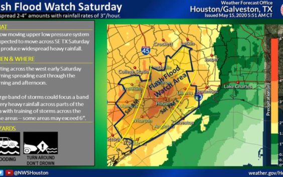
Flash flood watch for Houston ahead of torrential storms Friday and Saturday
-
A flash flood watch is in effect for much of the Houston area through Saturday, May 16, 2020.
A flash flood watch is in effect for much of the Houston area through Saturday, May 16, 2020.
Photo: National Weather Service
A flash flood watch is in effect for much of the Houston area through Saturday, May 16, 2020.
A flash flood watch is in effect for much of the Houston area through Saturday, May 16, 2020.
Photo: National Weather Service
The National Weather Service has issued a flash flood watch for all of the Houston area and its surrounding communities ahead of heavy rain expected over the next 36 hours.
The watch is set to expire Saturday evening as storms are pushed off the coast. Rain showers will start Friday afternoon and could dump up to nearly two inches by day’s end.
PUPPY RESCUE: Firefighters save dogs from house fire in north Houston
After a brief reprieve from showers overnight, more showers and thunderstorms will crop up Saturday starting around 7 a.m. and will last until the evening. Those storms could bring new rainfall totals close to five inches, according to the National Weather Service.
While the flash flood threat ends Saturday evening, lingering storms could still bring rain to the area Saturday night.
Sunday will have spotty showers. Mostly sunny skies and dry weather returns Monday, with highs in the upper-80s.
Jay R. Jordan covers breaking news in the Houston area. Read him on our breaking news site, Chron.com, and our subscriber site, HoustonChronicle.com | Follow him on Twitter at @JayRJordan | Email him at jay.jordan@chron.com