- Jaccob Slavin scores in OT as the Hurricanes beat the Capitals in Game 1 of their 2nd-round series
- 5 On Your Side: What happened to cars flooded during Hurricane Helene?
- Jamesville, North Carolina tornado given rare "EF-U" rating
- Ask the Meteorologist: What's the most concerning part of hurricanes in North Carolina?
- Austin removed from Tornado Watch; threat continues east of I-35
Cristobal regains tropical storm strength
The biggest impacts in Houston may be a few scattered showers… then HEAT!
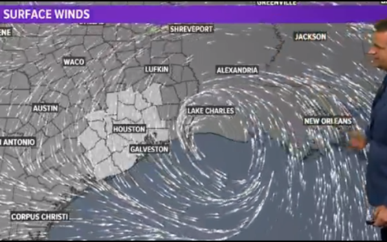
HOUSTON — Tropical Storm Cristobal formed in the Gulf of Mexico on Tuesday and is forecast to make landfall as a storm along the Louisiana coast early next week.
After being downgraded from tropical storm status to a tropical depression on Thursday, it picked up steam again Friday to once again be a tropical storm. Thursday and is expected to move north in the Gulf of Mexico.
Where will Cristobal go?
This is the latest forecast cone with timing from the National Hurricane Center.
The storm is expected to be ‘lop sided’ with almost all the heavy rain well east of the center. That means New Orleans and Louisiana may get most of the rain from Cristobal.
There is still a degree of uncertainty in the exact forecast track. Please stay close to the forecast this weekend.
Impacts to Houston?
Those in the direct path and on the right or “dirty side” of the storm can expect to get the heaviest rainfall. This includes much of Louisiana, as of the current forecast track. It’s not out of the question that Houston and much of Southeast Texas could also get scattered rain from Cristobal. Flooding and other severe weather issues are not expected to be an issue in Houston as of the latest update.