- Families of campers, counselors who died in Texas Hill County floods sue Camp Mystic
- Small plane bound for Jamaica with hurricane relief supplies crashes in Florida neighborhood
- Ask the Meteorologist: Did a tornado hit Johnston County Saturday night?
- Demolition begins on flood-damaged homes in Stoney Creek as neighbors await relief
- NC Office of State Fire Marshal aiding in Hurricane Melissa relief efforts
Triangle faces chance for severe weather into early Saturday ahead of Isaias
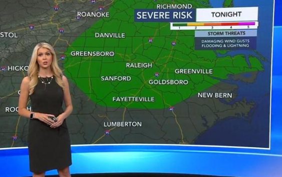
Raleigh, N.C. — Before eastern North Carolina feels any impacts of what is now Hurricane Isaias sometime Monday, severe storms could rock the overnight hours into early Saturday.
Meteorologist Kat Campbell reports a Level 1 risk for severe weather starting around 7 p.m. That chance will continue into the night and may linger into early Saturday.
“Storm chances are really going to go up after 7 o’clock (Friday night), and storm chances will hold at 40% even overnight and into the early morning hours,” Campbell said. “So don’t be surprised if you hear some rumbles of thunder, even overnight.”
The chance for severe weather extends as far west as Greensboro, as far south as Fayetteville and over to the Outer Banks and into Virginia. Campbell said damaging wind gusts, heavy rain and some lightning are possible.
Friday was a nice day in the Triangle and at the beaches, though it was another warm one. Much of the North Carolina coast is under a moderate to high rip current risk throughout the weekend, but other effects from Isaias won’t be felt until Monday.
This weekend, the coast could experience a few afternoon storms. By Monday, tropical storm or hurricane conditions are more likely. Periods of heavy rain and weak tornadoes will be possible along the coast as Isaias rain bands move in.
Temperatures in central North Carolina will be in the low 90s on Saturday with a 40% chance of rain. It’ll remain the same on Sunday before the effects from Isaias arrive early Monday.
There will be a chance for rain the rest of next week with temperatures in the upper 80s.