- Man charged with sparking the most destructive wildfire in Los Angeles history
- Carolina Hurricanes start 2025-26 season hosting New Jersey Devils
- Speedy Sparks, bassist for Texas Tornados, other San Antonio music icons, has died
- Authorities make an arrest related to deadly January wildfire that leveled LA neighborhood
- AI simulation gives Carolina Hurricanes 20% chance to win 2026 Stanley Cup
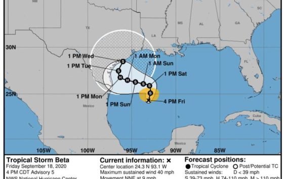
Tropical Storm Beta forms in Gulf of Mexico
-
Tropical Storm Beta formed Friday, Sept. 18, 2020.
Tropical Storm Beta formed Friday, Sept. 18, 2020.
Photo: National Hurricane Center
Tropical Storm Beta formed Friday, Sept. 18, 2020.
Tropical Storm Beta formed Friday, Sept. 18, 2020.
Photo: National Hurricane Center
Tropical Storm Beta formed in the Gulf of Mexico on Friday afternoon.
Forecasters say early next week will likely be filled with rain and thunderstorms for much of Southeast Texas and moderate flooding for Houston’s coastal communities.
Forecasters believe it could dump upwards of 10 inches of rain along parts of the Gulf Coast and produce moderate coastal flooding, according to the National Weather Service. Houston and other inland communities could lesser rainfall totals.
What the storm will do in the coming days is uncertain. Meteorologists with the National Hurricane Center have a large forecast cone predicting where the storm’s center will be in the coming days, which includes the entirety of the Texas coast.
Where will this storm land? Uuummm… Yes. #confused #spiral #txwx pic.twitter.com/LrL3o5P9Q0
— Mary Wasson (@Mary_Wasson) September 18, 2020
Even the spaghetti models have a wide array of possibilities pitching landfall anywhere near Brownsville to central Louisiana. The models also have the possibility that the storm would roll north along the coast.
For now, the storm is moving very slowly.
Saturday will likely be sunny with a high of 88 degrees. Rain chances kick off late Saturday.