- Families of campers, counselors who died in Texas Hill County floods sue Camp Mystic
- Small plane bound for Jamaica with hurricane relief supplies crashes in Florida neighborhood
- Ask the Meteorologist: Did a tornado hit Johnston County Saturday night?
- Demolition begins on flood-damaged homes in Stoney Creek as neighbors await relief
- NC Office of State Fire Marshal aiding in Hurricane Melissa relief efforts
Air quality begins to clear as wildfire haze moves out
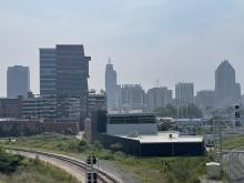
We’ve spent the last couple of days draped in smoke from wildfires from the western part of the United States and even Canada that traveled all the way across the country into made North Carolina.
The smoke prompted a Code Orange alert for air quality over nearly all of North Carolina on Thursday, but that alert is now set to expire at midnight. Air quality will improve slowly each day through the weekend with a moderate air quality forecast for Friday and Saturday, with things returning close to normal by Sunday.

As for the temperatures, expect more heat, but nothing too unseasonably warm. WRAL meteorologist Kat Campbell says we have a 30% chance at seeing showers Friday.
“A few afternoon thunderstorms are possible tomorrow with highs in the upper 80s,” Campbell said. “The weekend is seasonal with highs in the upper 80s to low 90s and partly cloudy skies. There is a slim chance of a thunderstorm Saturday,” she added.

Campbell also noted that Friday marks the return of a full moon and it should come with good visibility.
“Tomorrow is the full buck moon,” Campbell said. “There should be good viewing along with a few planets visible.”

Oh, and today marks 2 months until fall! :)