- Houston Cougars take on A&M Aggies in charity exhibition game supporting Hurricane Beryl relief
- Hurricane Helene donations delivered to Avery County for Share the Warmth campaign
- Old Crow Medicine Show founder talks music, hurricane relief and this weekend's big benefit show
- IV fluid shortage caused by hurricane to last for months
- 'It financially annihilated us': Pregnant mother displaced for 2nd time after western NC floods
Here we go again? Hurricane Michael could bring heavy rains to region
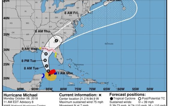
The current track for the storm would bring it through Eastern NC late Thursday
WILMINGTON – Nearly a month to the day after Hurricane Florence made landfall, another tropical storm has its eyes on the Carolinas.
Hurricane Michael is currently churning toward the Gulf of Mexico with a track that brings it onshore somewhere along the Florida panhandle early Thursday before cutting a northeastern path toward Eastern North Carolina.
As of 11 a.m. Monday morning, Michael was approaching the western tip of Cuba with sustained winds of 75 mph. The current track would bring it into the Cape Fear region late Thursday night.
Carl Morgan, a meteorologist with the National Weather Service’s Wilmington office, said the storm is forecast to stay slightly inland of the Wilmington area, but that won’t shield it from impacts including rain, wind and the potential for more coastal erosion.
“Right now, we could see 3-5 inches of rain, with locally higher amounts,” he said. “The storm is tracking parallel to the East Coast, but an onshore flow of air will build up water along the coast and could mean more storm surge and coastal erosion, which is concerning for those beaches that already saw a lot during Florence.”
Sustained winds of 30-plus mph and gusts in the 40-mph range are also forecast for the local region, Morgan said.
Alright the current track would spare the region from a direct hit, that path to the left of the Cape Fear comes with its own concerns.
“A track just inland would increase the possibilities of tornadoes in the area,” Morgan said.
If there is any saving grace with Michael making a pass at the Carolinas as it still recovers from Florence, its the speed at which it is traveling. Florence stalled over the region for more than a day, dumping rain and wind without reprieve. Michael won’t follow the same path.
“The fortunate thing is that is expected to be quick-moving storm,” Morgan said.
Although most residents will roll their eyes at the prospect of another storm hitting so close to Florence’s intense local impact, this is not uncommon for the thick of hurricane season.
“We are coming off the peak of season, so it is not that much of a surprise,” Morgan said. “But no extra water would be good at this point.”
Reporter Hunter Ingram can be reached at Hunter.Ingram@StarNewsOnline.com.