- Here's how to get your flooding debris picked up by the City of Houston
- Mosquito activity on the rise due to rainfall, flooding across Texas
- Volunteers help Conroe community clean up in wake of flooding in Montgomery County
- Why leaders are urging NC residents to start hurricane prep now
- Storms could produce hail, damaging winds south of Charlotte
Hurricane Michael is no Florence, but NC governor warns it could still cause damage
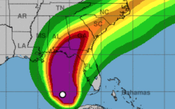
With Hurricane Florence still fresh in the minds of North Carolinians, Gov. Roy Cooper urged state residents to prepare for another storm.
Hurricane Michael, now churning in the Gulf of Mexico with winds up to 100 miles per hour, is expected to weaken to a tropical storm by the time it arrives in North Carolina starting late Wednesday night or Thursday morning. Forecasters say the storm will bring gusty winds and up to six inches of rain in central and eastern parts of the state before moving out Friday.
“I know people are fatigued from Florence,” Cooper said at a press briefing Tuesday morning. “But don’t let this storm catch you with your guard down.”
Michael is not expected to be a reprise of Florence, which pummeled the state for several days, producing record rainfall and river flooding, and has been blamed on 40 deaths in the state.
But the saturated ground left by Florence makes North Carolina more vulnerable. Wind gusts of 35 mph or more could bring down trees and powerlines and rip tarps off homes damaged by Florence, Cooper said. And while widespread river flooding is not expected, creeks and streams are likely to rise quickly and water could pool on roads.
“Because of the damage caused by Hurricane Florence, and the fact that there’s still some standing water in places, we have to be that much more alert about the damage that Hurricane Matthew could do,” Cooper said.
While Thursday’s weather will be lousy, Cooper said he was not aware of any cancellations, including the opening day of the N.C. State Fair in Raleigh. Forecasters expect Michael will be followed by the first true taste of fall weather in North Carolina this year, with sunny skies and high temperatures in the low 70s both Saturday and Sunday.