- California wildfire burns out of control but firefighters could get a break when winds diminish
- 'Flooding is our number one natural disaster' | Breaking down the voter-approved Harris County Flood Control District tax rate hike
- Powerful Category 3 Hurricane Rafael knocks out power in Cuba as it heads to the island
- NC Forest Service warns of increased wildfire risk in western part of state after Helene
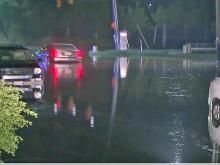
- First responders searched for hours after being told two people were swept away in flash flood
Triangle under tornado watch as Michael gets closer
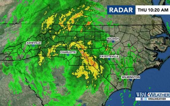
Raleigh, N.C. — Michael, now downgraded to a tropical storm, is poised to move into North Carolina and the Triangle later this morning, bringing gusty winds of up to 60 miles per hour and could drop 2-5 inches of rain in the area.
Top things to know about the storm:
- At least two deaths are now linked to Michael, one in Florida and one in Georgia.
- A tornado watch is in effect for parts of central North Carolina, including Cumberland County, as Michael moves north.
- The storm is moving about 20 miles per hour and could dump 3-6 inches of rain locally. The heaviest rain will be north and west of the Triangle.
- 16,600 power outages statewide have been reported so far. Henderson County officials report some water rescues have been performed.
- Several areas in central North Carolina are under a weather alert and there is a threat of tornadoes.
Hurricane Michael track | River flooding forecasts | School closings
Triangle impacts | Maps & webcams | Michael’s records
10:16 a.m.: Wake County is opening an emergency shelter at noon at Southeast Raleigh High School for people who need accommodations.
10:14 a.m.: Several Triangle counties are under a tornado watch as Tropical Storm Michael gets closer. The counties include Wake, Durham, Cumberland, Edgecombe, Orange and Nash.
WRAL meteorologist Elizabeth Gardner said the storm is moving north and expected to arrive mid-morning, most likely after the morning commute.
“Rain is going to pick up in intensity later this morning,” she said. “The heaviest rain will likely be from the Triangle northward.”
Several counties in central North Carolina are under a weather alert. For the full list: Weather Alerts
Several school districts have closed as the storm approaches the region. For the full list: Closings & Delays
Officials were monitoring several flood-prone areas around the Triangle and central North Carolina for the possibility of flash flooding. One of those areas is around Crabtree Valley Mall, which has a history of flooding.
Mall officials say they still anticipate opening at 10 a.m. Thursday, but they are closely watching the forecast and would revisit that decision if needed.
Gov. Roy Cooper’s decision on Wednesday to declare a state of emergency means 150 National Guard troops are on standby and can provide assistance if needed. The state’s Emergency Operations Center has also been activated.
After Michael leaves NC, fall arrives
Once the storm moves out, weather conditions will greatly improve around the Triangle, which will see its first taste of fall.
Brisk, crisper air will move in with overnight lows that will dip to the upper 40s Friday night in Saturday.

Michael makes landfall in Florida
The most powerful hurricane on record to hit Florida’s Panhandle left wide destruction and at least two people dead and wasn’t nearly finished Thursday as it crossed Georgia, now as a tropical storm, toward the Carolinas, that are still reeling from epic flooding by Hurricane Florence.
A day after the supercharged storm crashed ashore amid white sand beaches, fishing towns and military bases, Michael was no longer a Category 4 monster packing 155 mph (250 kph) winds. As the tropical storm continued to weaken it was still menacing the Southeast with heavy rains, blustery winds and possible spinoff tornadoes.
Authorities said at least two people have died, a man killed by a tree falling on a Panhandle home and according to WMAZ-TV, an 11-year-old girl was also killed by a tree falling on a home in southwest Georgia. Search and rescue crews were expected to escalate efforts to reach hardest-hit areas and check for anyone trapped or injured in the storm debris.
The National Hurricane Center in Miami said the eye of Michael was about 25 miles (40 kilometers) east of Macon in central Georgia at 2:00 a.m. Thursday. The storm had top sustained winds of 60 mph (96 kph) and was moving to the northeast at 20 mph (32 kph).
After daylight Thursday residents of north Florida would just be beginning to take stock of the enormity of the disaster.
Damage in Panama City near where Michael came ashore Wednesday afternoon was so extensive that broken and uprooted trees and downed power lines lay nearly everywhere. Roofs were peeled away, sent airborne, and homes were split open by fallen trees. Twisted street signs lay on the ground. Palm trees whipped wildly in the winds. More than 380,000 homes and businesses were without power at the height of the storm.
Vance Beu, 29, was staying with his mother at her home, Spring Gate Apartments, a complex of single-story wood frame buildings where they piled up mattresses around themselves for protection. A pine tree punched a hole in their roof and his ears even popped when the barometric pressure went lower. The roar of the winds, he said, sounded like a jet engine.

“It was terrifying, honestly. There was a lot of noise. We thought the windows were going to break at any time,” Beu said.
Sally Crown rode out Michael on the Florida Panhandle thinking at first that the worst damage was the many trees downed in her yard. But after the storm passed, she emerged to check on the cafe she manages and discovered a scene of breathtaking destruction.
“It’s absolutely horrendous. Catastrophic,” Crown said. “There’s flooding. Boats on the highway. A house on the highway. Houses that have been there forever are just shattered.”
")
A Panhandle man was killed by a tree that toppled on a home, Gadsden County Sheriff’s Office spokeswoman Anglie Hightower said. But she added emergency crews trying to reach the home were hampered by downed trees and debris blocking roadways. The debris was a problem in many coastal communities and still hundreds of thousands of people were also left without power.
Gov. Rick Scott announced afterward that thousands of law enforcement officers, utility crews and search and rescue teams would now go into recovery mode. He said “aggressive” search and rescue efforts would get underway.
“Hurricane Michael cannot break Florida,” Scott vowed.
Michael sprang quickly from a weekend tropical depression, going from a Category 2 on Tuesday to a Category 4 by the time it came ashore. It forced more than 375,000 people up and down the Gulf Coast to evacuate as it gained strength quickly while crossing the eastern Gulf of Mexico toward north Florida. It moved so fast that people didn’t’ have much time to prepare, and emergency authorities lamented that many ignored the warnings and seemed to think they could ride it out.
")
In Panama City, plywood and metal flew off the front of a Holiday Inn Express. Part of the awning fell and shattered the glass front door of the hotel, and the rest of the awning wound up on vehicles parked below it.
“Oh my God, what are we seeing?” said evacuee Rachel Franklin, her mouth hanging open.
Based on its internal barometric pressure, Michael was the third most powerful hurricane to hit the U.S. mainland, behind the unnamed Labor Day storm of 1935 and Camille in 1969. Based on wind speed, it was the fourth-strongest, behind the Labor Day storm (184 mph, or 296 kph), Camille and Andrew in 1992.
It also brought the dangers of a life-threatening storm surge.
In Mexico Beach, population 1,000, the storm shattered homes, leaving floating piles of lumber. The lead-gray water was so high that roofs were about all that could be seen of many homes.
Hours earlier, meteorologists watched satellite imagery in complete awe as the storm intensified.
")
“We are in new territory,” National Hurricane Center Meteorologist Dennis Feltgen wrote on Facebook. “The historical record, going back to 1851, finds no Category 4 hurricane ever hitting the Florida panhandle.”
The storm is likely to fire up the debate over global warming. Scientists say global warming is responsible for more intense and more frequent extreme weather, such as storms, droughts, floods and fires. But without extensive study, they cannot directly link a single weather event to the changing climate.
After Michael left the Panhandle late Wednesday, Kaylee O’Brien was crying as she sorted through the remains of the apartment she shared with three roommates at Whispering Pines apartments, where the smell of broken pine trees was thick in the air. Four pine trees had crashed through the roof of her apartment, nearly hitting two people.

Her biggest worry: finding her missing 1-year-old Siamese cat, Molly.
“We haven’t seen her since the tree hit the den. She’s my baby,” a distraught O’Brien said, her face wet with tears.
___
Associated Press writers Tamara Lush in St. Petersburg, Florida; Terry Spencer in Fort Lauderdale, Fla.; Freida Frisaro in Miami; Brendan Farrington in St. Marks, Florida; Russ Bynum in Keaton Beach, Florida; Jonathan Drew in Raleigh, North Carolina; and Seth Borenstein in Kensington, Maryland, contributed to this story.