- Houston Cougars take on A&M Aggies in charity exhibition game supporting Hurricane Beryl relief
- Hurricane Helene donations delivered to Avery County for Share the Warmth campaign
- Old Crow Medicine Show founder talks music, hurricane relief and this weekend's big benefit show
- IV fluid shortage caused by hurricane to last for months
- 'It financially annihilated us': Pregnant mother displaced for 2nd time after western NC floods
Tropical Storm Michael brings heavy rain, strong wind gusts to Triangle
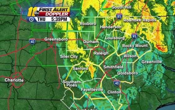
Tropical Storm Michael is starting to pull out of central North Carolina, pushing north/northwest as the storm spins toward Virginia. Though the rain has tapered off, high winds caused the biggest problems, knocking down scores of trees, leading to blocked roadways and thousands without power.
Stay on top of breaking news stories with the ABC11 News App
A cold front is colliding with the back edge of the storm and as it spins through, starting about 7 p.m., the winds could push near 50 mph.
The good news is that rain totals in the Triangle have been slightly lower than forecast (about 2 to 4 inches) so most flash flooding should recede quickly once the rain stops.
Hurricane Michael is blamed for at least six deaths, including one in western North Carolina. The storm hit the Florida Panhandle on Wednesday afternoon and swept through Georgia before entering the Carolinas.
While the hurricane has weakened to a tropical storm, Gov. Roy Cooper said people should still take precautions.
“Inland hurricanes and tropical storms are life-threatening and can do just as much damage as coastal storms,” Cooper said.
“I want all North Carolinians to be on alert — from storm surge on the coast to strong winds in the eastern and central parts of NC, to rain in the Piedmont and the west. Travel can be treacherous right now, so you should stay off the roads if you can,” Cooper said. “At least 16 roads have already been closed due to Michael.”
In Raleigh, a stretch of Capital Boulevard was closed because of flooding.
A Tornado Watch is in effect for much of North Carolina and Virginia.
The watch lasts until 9 p.m. in multiple counties including Cumberland, Wake, Chatham, Durham, and Franklin.
RELATED: School delays, closings for Friday
Michael was said to be the most powerful hurricane on record to hit Florida’s Panhandle.
The devastating storm was downgraded to a Tropical Storm and is expected to arrive in North Carolina late Thursday morning.
Timeline of the storm
9 a.m.: Rainfall starts in the Sandhills
11 a.m. – 2 p.m.: Heavier rain starts to fall across the area
3 p.m. – 7 p.m.: Heaviest rainfall occurs
7 p.m.: Heavy rains start to taper off, dry spots form
8 p.m. – 10 p.m.: Storm pushes out of the area
Rainfall amounts will average 2-4″ inches.
Areas near Raleigh can expect to see between 2-4″, areas surrounding Person County could see 5-7″, and the coastal region could see between 1-3″.
Local power outages and minor structural damage will be possible; Duke Energy is expecting between 300,000 to 500,000 outages in the Carolinas.
Local rivers and streams, which were recently affected by Hurricane Florence, could see some flooding from Tropical Storm Michael.
Cape Fear River crests higher than Hurricane Matthew
On Wednesday, the Cape Fear River crested high than it did during Hurricane Matthew.
Some rivers are expected to crest — or reach the highest stage or level of a flood wave as it passes a particular point — at moderate flood stage Friday night and Saturday morning.
(Copyright ©2018 ABC11-WTVD-TV/DT. All Rights Reserved – The Associated Press contributed to this report.)