- WATCH: Video Shows Confirmed Tornado touches down in Columbus County
- Residents begin clean up after storms, apparent tornado roll through NC Tuesday
- Flooding lingers in Liberty County neighborhoods near Trinity River with more rainfall expected
- North Carolina behind on hurricane preparedness, study shows
- North Carolina way behind on hurricane preparedness, study shows
Nasty today, nastier tomorrow; Triangle under flood watch
Raleigh, N.C. — As drizzle fell Wednesday evening in the Triangle, WRAL meteorologist Mike Maze said Thursday will be the “grand finale” of the rainy week.
Light rain will continue to fall overnight, but the precipitation will begin to get heavier at about 5 a.m. Thursday.
“It’s nasty today, and it’s only going to get nastier tomorrow,” Maze said.
Maze said the worst of the rain should begin at about 7 a.m. in the southern counties and end at about 3 p.m. in the northeastern counties. The bulk of the rain should be over in the Triangle by about 1 p.m. Thursday, he said.
“The afternoon commute will be far drier than the morning commute,” he said of Thursday.
The Triangle has seen more than 2 inches of rain since Monday, and Maze said another 1 to 3 inches of rain are possible Thursday. As a result, a flood watch has been issued from 7 p.m. Wednesday through 7 p.m. Thursday.
“Flooding along area creeks, streams and rivers will be a concern,” WRAL meteorologist Aimee Wilmoth said. “The ground is completely saturated, and there is simply nowhere for the water to go.”
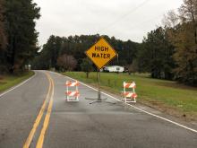
Maze said the rain will cause ponding on area roadways Thursday, and flood warnings and flash flood advisories are possible throughout the area.
Counties south and west of Raleigh were seeing flooding Wednesday morning and were under flood warnings. Several rescues were reported.
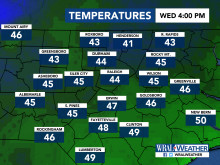
The good news is that the weekend will be pleasant, with highs at least 10 degrees warmer than they were Wednesday and Thursday.
Friday will be sunnier with a high in the mid 50s, and Saturday and Sunday should be mild with highs in the upper 50s to low 60s.
Rain will not be a threat on Saturday for the Raleigh Christmas Parade and Winter Wonderland.
