- Even light rain causing flash flooding issues on Houston's north side
- LIST: High water locations, street flooding as heavy rain falls in the Houston area
- China on Alert for Heavy Rain and Floods From Typhoon Gaemi
- Flash flood threat; A day to be Weather Aware
- Power-Thirsty Bitcoin Miners Are Flooding the Energy Center of Texas
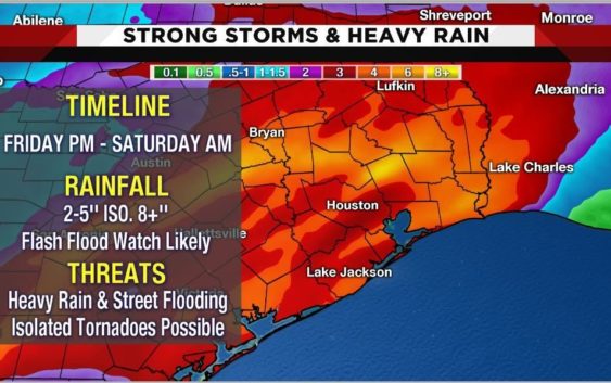
Severe storms, possible flooding expected Friday into Saturday
HOUSTON – While weather has been cool, sunny and beautiful this week skies will turn dark as we head into the weekend.
A strong weather system has been lashing the West Coast and is on the way to Southeast Texas.
Shower and storms chances will go up Friday afternoon but the worst of the weather will move in late Friday night and last through early Saturday morning.
In a matter of eight to 12 hours a widespread 2 to 5 inches of rain will soak Southeast Texas with isolated areas being hit hard by 8 to 10′ inches of rain. Heavy rain and street flooding will be the largest concern.
With the worst of the weather happening overnight into Saturday morning, most will be safe and at home, but it is important to note that driving late Friday night into Saturday morning could be treacherous.
Street flooding is a large concern. Quick rises could also occur on local creeks and bayous. It will be important to monitor current weather and road conditions when heavy rain sets in.
Severe weather is a lower threat but possible with the system we are tracking.Isolated tornadoes are possible Friday night into Saturday morning.
The fast moving system will clear by Saturday afternoon and the remainder of the weekend will be sunny, chilly and dry.
Copyright 2018 by KPRC Click2Houston – All rights reserved.