- Governor Cooper to reveal crucial disaster recovery plan for Hurricane Helene relief Wednesday
- Active-duty military winding down Hurricane Helene recovery mission in western North Carolina
- Right-wing political activists call for NC lawmakers to decide 2024 presidential election results after Hurricane Helene's impact
- Grove Park Inn cancels National Gingerbread House Competition for 2024 due to Hurricane Helene devastation
- Trump makes more debunked claims about FEMA as he surveys storm damage in North Carolina
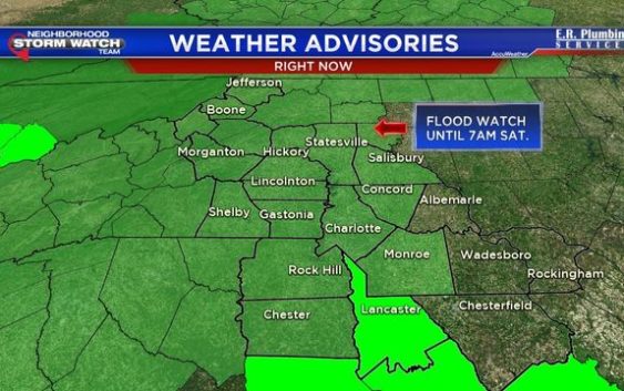
Flood Watch: Heavy rain, thunderstorms possible
CHARLOTTE, N.C. (FOX 46 CHARLOTTE) – Rain is the big story once again! Grab your umbrella, you are going need it through Friday!
As the storm system over the Midwest inches closer to the area today we will see some scattered showers beginning to pop us this afternoon. The rain will gradually increase across the area overnight into Friday, so be prepared for a slower commute on Friday morning.
Keep an eye out for heavy rain at times on Friday and even a couple of thunderstorms with gusty winds. By the time the rain moves out Friday evening, rainfall totals will add up to around 1-3 inches.
A Flood Watch has been issued for most of our area until 7 a.m. Saturday. A Wind Advisory is in effect for some mountain neighborhoods until 1pm Friday, with gusts to 40-50 mph possible.
We will dry out a bit on Saturday before the next storm system moves in by Sunday. Rain will once again be possible from Sunday through the New Year.
Thursday: Mostly cloudy with scattered PM showers. High 48.
Tonight: Cloudy with rain. Low 46
Friday: Rain, heavy at times. Gusty winds and minor flooding possible. High 67