- $40 million to go to underserved SC counties for Hurricane Helene recovery. Here's what you need to know.
- Family honors Air Force veteran Derwin Anderson Jr. after he died in June flash floods
- City of Wilmington addresses flooding on New Centre Drive
- Harnett County fire: Two homes damaged
- Medical examiner identifies 13th victim from massive flash flood in San Antonio
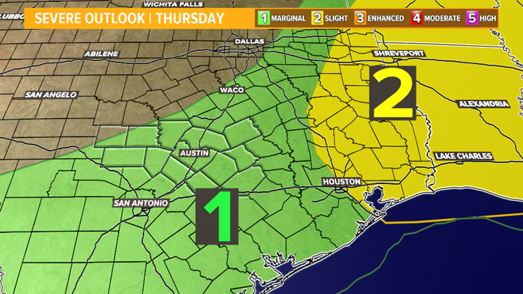
Flooding concerns return Thursday through Saturday
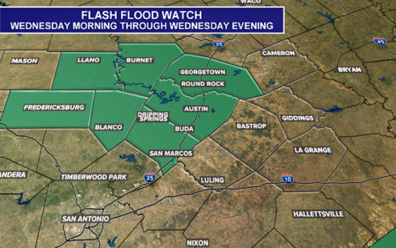
AUSTIN, Texas — Flash Flooding continues to be a top concern for Central Texas residents. A Flash Flood Watch will be in effect Wednesday evening until 7pm for metro counties and for most of the Hill Country.

kvue
A flood warning has been issued for the Pedernales River at Johnson City until Thursday evening. The river is expected to crest at 17.3′.
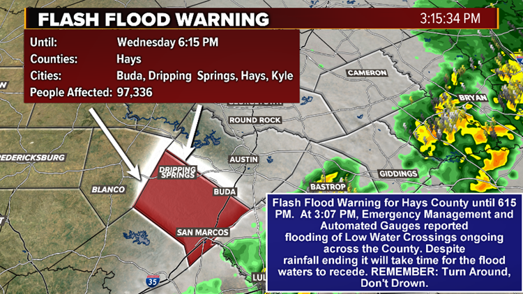
There is also a flash flood warning in place for Hays County until 6:15 p.m. after heavy rain impacted the region.

KVUE
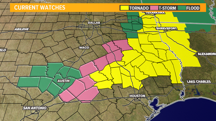
As for the remainder of the day, storm watches including Flash Flood, Thunderstorm, and Tornado watches extend outside the Central Texas area, into East Texas, portions of Louisiana, Oklahoma, and Arkansas.
KVUE
WATCH: The Importance of “Turn Around, Don’t Drown”
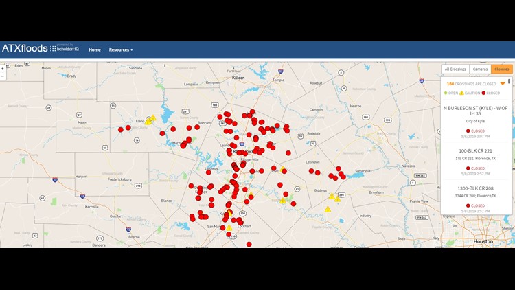
Some low water crossings are closed due to heavy rainfall and more will likely close as heavy rain moves into the Austin area.
KVUE
Be sure to stay out of flooded areas. You can find out what low water crossings are closed by clicking here.
As storms moved over Kerrville before 7:30 a.m. Wednesday, golf ball-sized hail was reported there.
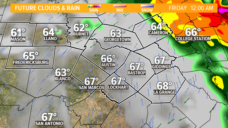
TONIGHT: Our strong storm threat is expected to diminish in the overnight before light showers return to the region tomorrow. Currently a Flash Flood Warning for Hays County is in effect through late evening.
KVUE
The bottomline is rain chances is expected to increase as a cold front moves across Central Texas Thursday afternoon.
KVUE
This could bring renewed chances for strong to severe thunderstorms, damaging wind gusts, hail, and more flooding.

KVUE
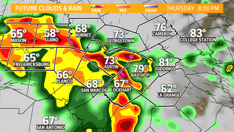
Expect a strong pattern of scattered to strong thunderstorms building in the Hill Country around dinner time and becoming even stronger closing in on the IH-35 corridor.
KVUE
Once we enter the 8pm hour, storms could ignite very heavy rain, wind gusts exceeding 50 to 60 mph and hail.
KVUE
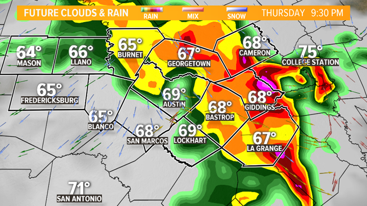
Activity will continue to train in moderate to heavy rain through the late evening moving east. Timing and progression of the storms will be critical as some areas have been completely saturated for days now.
KVUE
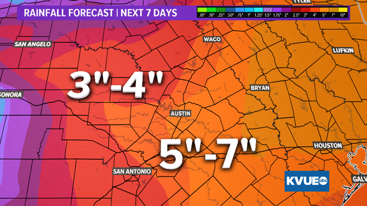
Rainfall amounts over the next several days could range from three to four inches for areas from Austin westward, and five to seven inches for areas from Austin eastward.
kvue
May is typically our wettest and most active time of the year when it comes to severe weather and this forecast is a testament to that. Stay up to date with KVUE as we continue through the severe weather season here in Texas. Download KVUE’s app for updates and follow KVUE on YouTube, Facebook, Twitter and Instagram.
RELATED:
Colorado River levels dropping downstream from Austin
LCRA to open floodgate at Tom Miller Dam
Two floodgates opened at Longhorn Dam in East Austin after recent flooding
VIDEO: Flooding at Barton Springs Pool
PEOPLE ARE ALSO READING:
‘Game of Thrones’ left a coffee cup in this week’s episode and the internet is losing it
San Marcos police investigating apparent murder-suicide of Texas State students
The 17 best deals and freebies for Teacher Appreciation Day and week