- Hill Country flooding death toll rises to 32 as search continues for missing girls, other survivors
- Tropical Storm Chantal expected to make landfall overnight in coastal South Carolina
- Severe weather, flooding forces MLS to postpone Austin FC vs. LAFC match at Q2 Stadium
- Hill Country flooding: Here’s how to give and receive help
- LCRA advises caution on lakes amid Central Texas flooding
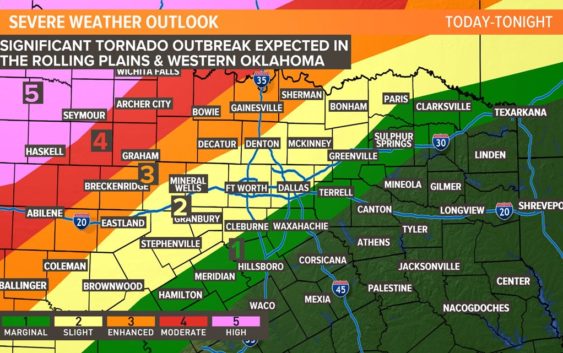
Severe storms, tornadoes possible from Texas Panhandle into Oklahoma

Heads up North Texas! A warm front is lifting north, bringing a surge of moisture into our area. That leaves a small window of time for isolated severe storms for Monday.
A significant severe weather outbreak is expected across Oklahoma and the eastern part of the Texas Panhandle Monday.
If storms form, they would be capable of all modes of severe weather while racing north into Oklahoma.
Otherwise, mostly cloudy skies, windy and warm through late afternoon. Highs climb into the mid-upper 80s with gusty southeast winds of 20-30 mph.
After midnight, widespread storms are expected to move through with damaging winds and heavy rain threat for the morning commute.
After multiple rounds of severe storms expected northwest of North Texas for Monday, the final round will likely form a line, marching into North Texas after 12 a.m. Storms are expected to weaken as they near the area. However, wind and hail still possible. Either way, plan for a messy morning commute Tuesday.
Storms move east by midday with a damaging wind and hail threat for areas east of DFW during the afternoon on Tuesday. Quiet weather and warm temperatures are expected for the rest of the week.
TODAY: Scattered storms possible this afternoon (40%), mostly cloudy, windy & warm. Winds: S 20-30. High: 86.
TONIGHT: Storms possible after midnight. (50%). Winds: SE 15-25. Low: 70.
TUESDAY: Storms likely in the morning (70%). Winds: SW 15-25. High: 82.
Remember to download the WFAA app to check one of our dozens of local radars near you as well as the latest forecast, cameras and current conditions.
Check Weather Alerts here.