- Austin leaders consider expanding wildfire protection plan
- Large hail, strong winds and tornado threat possible into Thursday evening
- Large hail, tornado threat possible Thursday evening
- Jaccob Slavin scores in OT as the Hurricanes beat the Capitals in Game 1 of their 2nd-round series
- 5 On Your Side: What happened to cars flooded during Hurricane Helene?
Severe weather threat for the Triangle has been raised
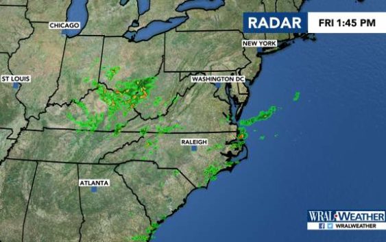
Raleigh, N.C. — The National Weather Service has placed much of the Triangle under a Level 3 risk for storms this afternoon, turbulent weather that will snap the streak of long, dry hot days that have blanketed the region.
The elevated risk includes Wake and Chatham counties as well as areas to the south and east of those counties.
“It’s fairly unusual for us to see a Level 3 risk for severe weather,” said WRAL meteorologist Elizabeth Gardner, adding that areas under the threat could see wind damage and heavy rain. “These are storms we’ll want to take more seriously.”
As of 1:35 p.m., much of the Triangle was under a severe thunderstorm watch until 11 p.m.
The threat of severe weather Friday comes on the heels of stray storms that popped up around areas south of Fayetteville, which saw reports of downed trees and damaged buildings after storms Thursday night.
Those storms will continue into the evening, with even more clusters of severe weather developing around 8 p.m.
Most will move east out of our area by midnight.
Temperatures will reach 90 degrees on Friday.

There’s a 30 percent chance of rain on Saturday as Friday’s cold front stalls. The high will be 87 degrees.
Sunday has another 30 percent chance of rain, with temperatures reaching 88 degrees.
Temperatures are expected to stay in the 80s next week.
