- Severe weather leads to fallen trees, car crashes and flooding around the Triangle
- New video shows vehicles being swept away in historic, deadly flash floods in SA on June 12
- $40 million to go to underserved SC counties for Hurricane Helene recovery. Here's what you need to know.
- Family honors Air Force veteran Derwin Anderson Jr. after he died in June flash floods
- City of Wilmington addresses flooding on New Centre Drive
Wet weekend forecast: Flooding possible after early, heavy rain
A steady, sometimes heavy, rain will fall throughout the day Saturday, and the forecast for Sunday looks no less gloomy.
“We do have soaking rain showers in the forecast for today. It is not the day to plan a long hike outdoors,” WRAL meteorologist Peta Sheerwood said.
A mix of systems will keep things soggy. An upper-level low is meeting moisture from a tropical system over the Carolinas, and those conditions will get stuck in the Southeast.
A blocking ridge in the Northeast will means those systems will take until Monday or Tuesday to move out.
But another system moves in Tuesday or Wednesday, bringing more rain.
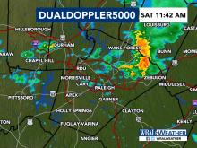
Low-lying areas in Durham see flash floods
Saturday began with rumbles of thunder and some pockets of heavy rain in Durham. A series of showers marked a trail from southwest to northeast through central North Carolina. Roads were wet and visibility low at sunrise.
During the 8 o’clock hour, rain was falling in parts of eastern North Carolina at a rate of more than 2 inches per hour, Sheerwood said.
By 9 a.m., some low-lying areas reported flash flooding. The National Weather Service issued a flood advisory that included Wake, Durham, Wayne, Franklin, and Granville counties.
“If you are traveling today, keep in mind, flooding will be an issue,” Sheerwood said.
The flooding risk for Raleigh and Durham through Saturday is low, but that risk increases to the west. Charlotte and Greensboro are under a high risk for flooding.
Showers any time, with breaks of dry skies
Overall, there is a 70 percent chance for rain Saturday and a 60 percent chance for rain Sunday.
“You will need a jacket or umbrella throughout the day to keep dry,” Sheerwood said.
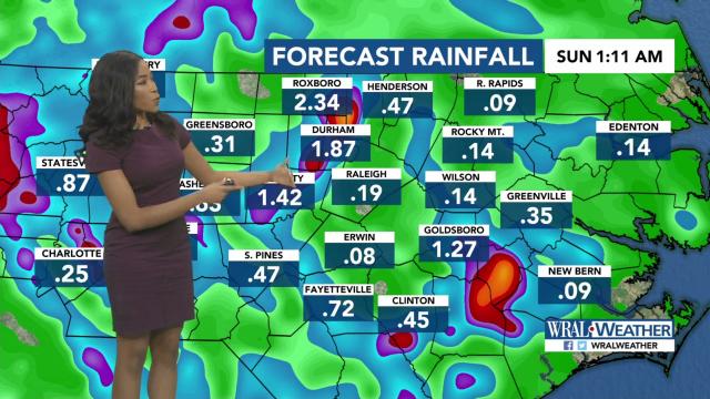
As much as 2 to 4 inches of rain could fall over the next five days.
“We could see showers and storms at any time throughout the day, but we think the better chances will come later in the day with the best heating,” WRAL meteorologist Mike Maze said.
Forecast models had just about an inch of rain falling over Raleigh through Sunday, but predicted more than 2 inches for Durham, Roxboro, Goldsboro and Clinton.
The cloud cover will keep it cooler – Saturday’s forecast high is only 77 degrees.
“The showers and storms will be quite numerous, but there will be periods where it will be dry. It’s just impossible to time when the dry periods will be in your neighborhood,” Maze said.
Sunday morning could see some dry spots before showers and storms start again in the afternoon.

“The rain is here to stay,” Maze said.
High temperatures will be near 80 degrees during the weekend, and low temperatures will be closer to 70.
Monday has another 60 percent chance for rain, and there’s a 70 percent chance for rain on Tuesday and Wednesday.

“All I can tell you is have the umbrellas ready over the next several days,” Maze said.