- Houston Cougars take on A&M Aggies in charity exhibition game supporting Hurricane Beryl relief
- Hurricane Helene donations delivered to Avery County for Share the Warmth campaign
- Old Crow Medicine Show founder talks music, hurricane relief and this weekend's big benefit show
- IV fluid shortage caused by hurricane to last for months
- 'It financially annihilated us': Pregnant mother displaced for 2nd time after western NC floods
Tropical Storm Dorian expected to become hurricane Wednesday
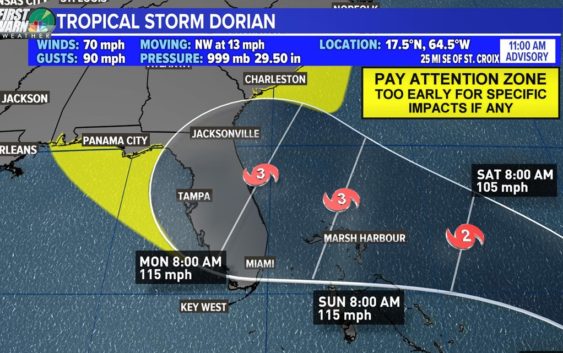
CHARLOTTE, N.C. — Tropical Storm Dorian strengthened slightly Wednesday morning as it makes it way toward Puerto Rico and the Virgin Islands. Authorities warned of landslides, widespread flooding and power outages. President Donald Trump declared an emergency Tuesday night and ordered federal assistance for local authorities.
Maximum sustained winds have increased to nearly 60 mph, with higher gusts, and the storm is moving northwest at 13 mph, according to the National Hurricane Center’s latest advisory. Dorian is about 240 miles east-southeast of Ponce, Puerto Rico.
Forecasters believe Dorian will move near or to the east of Turks and Caicos and the southeastern Bahamas Thursday night and near or to the east of the central and northwestern Bahamas on Friday and Saturday.
Tropical-storm-force winds are currently extending out up to 45 miles from Dorian’s center.
A hurricane watch is in effect for Puerto Rico, and tropical storm warnings are in effect for Puerto Rico, Vieques, Culebra, the U.S. and British Virgin Islands, and the Dominican Republic — from Isla Saona to Samana.
If it holds together, it could move over the Bahama and towards the coast of Florida over the long Labor Day weekend – – but it’s still early to know exactly where it will go and how strong it will be when it gets there.
This many days out, the forecast has a wide level of uncertainly. First Warn Chief Meteorologist Brad Panovich advises anyone from South Carolina through Florida and on to Texas to “pay attention” and keep monitoring the forecast.
On the current forecast track, the center of Dorian will move across the northeastern Caribbean Sea on Tuesday night pass over or near western and central Puerto Rico on Wednesday, and move near or just east of eastern Hispanola on Wednesday night.
Tropical Depression Six
Tropical Depression Six remains well off the Atlantic coast and away from land. It poses no threat to the mainland United States.
As of 5 pm Tuesday, it was centered about 410 west of Bermuda or about 315 miles southeast of Cape Hatteras and moving north-northwest at 7 mph. Maximum sustained winds remain at 35 mph.
According to the National Hurricane Center, some strengthening is occurring. It is expected to become a tropical storm on Wednesday, taking on the name Erin. However, it should begin to take on extratropical characteristics and weaken on Thursday as it moves away from land.
RELATED: FORECAST: Cloudy with a few showers overnight
RELATED: Person struck by lightning in Marion, numerous tress toppled during storms
RELATED: Lightning strikes kill 5, injure over 100 in eastern Europe’s Tatra Mountains
RELATED: Extensive tree damage in Statesville after severe weather
RELATED: Two rescued from flooded car during Charlotte storms