- WATCH: Video Shows Confirmed Tornado touches down in Columbus County
- Residents begin clean up after storms, apparent tornado roll through NC Tuesday
- NC State researchers find increased fecal contamination in coastal waters due to sunny day flooding
- Flooding lingers in Liberty County neighborhoods near Trinity River with more rainfall expected
- North Carolina behind on hurricane preparedness, study shows
Hurricane Dorian LATEST: Storm could be low-end Category 4 at Florida's coast
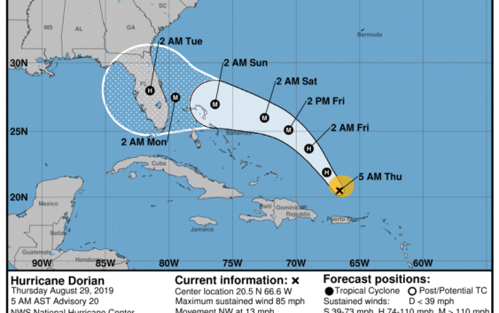
Florida’s east coast continues to be smack in the middle of Hurricane Dorian’s sights with the storm’s path changing little overnight but its potential strength growing, according to the National Hurricane Center’s 5 a.m. update.
Dorian is a Category 1 hurricane now but is expected to reach major hurricane status in the next day or two and maintain that power until landfall.
The forecast puts Dorian just off Florida’s central coast as a strong Category 3 storm, with winds up to 125 mph, in the wee hours of Monday morning.
That is just shy of the 130 mph threshold for a Category 4 storm.
Weather Underground meteorologist Bob Henson said Dorian’s path puts it in “near ideal territory for strengthening.”
That includes light to moderate wind shear and very warm water with sea surface temperatures of between 84 and 86 degrees.
“Dorian is already more organized than expected at this point, and it is now in a position to take advantage of classic atmospheric and oceanic conditions that will support several days of strengthening and perhaps one or more rounds of rapid intensification,” Henson said in his Cat 6 column.
Table of top 10 strongest (ranked by pressure) Florida #hurricane landfalls on record (since 1851). Hurricane Michael ranks 2nd and Hurricane Irma ranks 8th. #HurricaneDorian pic.twitter.com/QxKIOwNzxX
— Philip Klotzbach (@philklotzbach) August 29, 2019
The center line of that forecast brings the storm ashore in or near Brevard County, but meteorologists note the models continue to diverge two days out and the center path isn’t a certain one. The cone of possibility stretches from the Northern Keys to the southern Georgia coast.
Though landfall has fallen back to Monday, tropical storm conditions in South Florida, including wind gusts of 39 mph or more, could arrive as early as Saturday evening. By Sunday, those conditions are likely to prevail across the peninsula.
After making landfall, Dorian is expected to plow inland as a Category 2 hurricane, according to the hurricane center.
“The situation is becoming increasingly dangerous and life-threatening,” National Weather Service meteorologists in Melbourne wrote this morning. “Hurricane Dorian is placing all east central Florida at risk.”
The next advisory from the National Hurricane Center will be at 11 a.m. There are only intermediate advisories when there are watches or warnings in effect.
LIVE TRACKING: Follow Hurricane Dorian on The Pam Beach Post’s live tracking map
The forecast is a radical shift from Dorian’s more humble beginnings. Just days ago expected to arrive in the Sunshine State as a tropical storm, Dorian instead sailed past the wind-shredding Caribbean islands and into a warm Atlantic clear of obstacles to its intensification.
Florida Gov. Ron DeSantis declared a state of emergency Wednesday for 26 counties in Dorian’s path – a sprawling area from Jacksonville to Key Largo that will tighten as the storm churns closer to the coast.
Areas covered by the state of emergency include all coastal counties from Duval through Monroe and inland counties including Okeechobee, Glades, Highlands, Orange and Hendry.
“It’s important for Floridians on the east coast to monitor this storm closely,“ DeSantis said. ”Every Florida resident should have seven days of supplies, including food, water and medicine, and should have a plan in case of disaster. I will continue to monitor Hurricane Dorian closely with emergency management officials.“
Here are the 5 AM AST/EDT August 29 Key Messages for Hurricane #Dorian. For more information, visit https://t.co/tW4KeFW0gB pic.twitter.com/IPNcswUGBt
— National Hurricane Center (@NHC_Atlantic) August 29, 2019
Across the state, residents are heeding the warnings, typical Labor Day burger and bun shopping has been eclipsed by shelve-clearing runs on supplies from bottled water to batteries.
At 5 a.m. Dorian was about 150 miles north northwest of San Juan, Puerto Rico and 425 miles southeast of the Bahamas with maximum sustained winds of 85 mph. The storm is moving northwest at 13 mph.
The South Florida Water Management District is in an “enhanced monitoring level”, and working to drain canals to make room for rainfall that its meteorologists said could be 8 to 12 inches through Labor Day.
A new moon Friday is also expected to swell tides through the weekend. That means an increased chance of flooding along the Intracoastal.