- Residents begin going through the rubble after tornadoes hammer parts of Nebraska and Iowa
- Midwest tornadoes flatten homes in Nebraska suburbs and leave trails of damage in Iowa
- WATCH: Massive tornado caught on camera in Iowa
- List of 2024 hurricane names
- Severe weather increases risk of power outages
Heavy rain could cause flash flooding this week in Houston
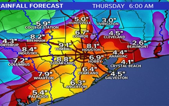
HOUSTON — Very heavy rain is on the way for southeast Texas as a slow moving tropical wave works its way towards the Texas coast. The on-slot of tropical rains moving at a snails pace could spell flood issues over the next few days.
New Monday Afternoon:
– Flash Flood Watches are likely area wide by tonight or Tuesday
-Computer models have dramatically increased the amount of rain we could see around the region.
-The National Hurricane Center now says this area of low pressure in the gulf has a 20% chance of development over the next few days, a slight increase from the 10% on Sunday.
What to Expect:
Rain and possibly a lot of it. As mentioned, computer models have drastically increased the amount of rain we could potentially see with this slow moving tropical wave.
The KHOU weather team is forecasting up to 9 inches of rain for a large swath of southeast Texas but some areas could see totals over 12 inches.
While the ground is dry and much of Texas is in the midst of mild drought conditions, we’ll be able to absorb a lot of the water initially. However with rain rates as high as 2 to 3 inches per hour, that could quickly lead to run off and quick ponding of usual suspect spots including low-lying roads and freeways (think feeders and I-45 north at Main St) along with other area side streets.
As we know well here in Houston, tropical waves often have a trick or two up their sleeve and while we’re confident it will rain, totals will be a watch and wait kind of deal. Certainly 8 to 10 inches with isolated amounts over a foot can’t be ruled out.

khou
Timeline:
Monday: We will likely wake up to some coastal showers that will work their way through the coastal areas. By the afternoon and the heat of the day, we could see these move into the I-10 corridor. Chance of rain Monday stands at 30%.
Tuesday: The rain will become even more widespread. Like Monday, we’ll start with some coastal showers that will progress inland as we get into the afternoon. This time, even the inland counties are likely to get in on some of the action. Chance of rain stands at 60%.
Wednesday and Thursday: both days should see widespread coverage of showers and thunderstorms. Locally heavy rainfall will be possible with some rain rates reaching 2 to 3 inches per hour. All counties, especially south of I-10 will be prone to localized flooding and flash flooding. Some areas could tally 5 to 7 inches and some areas even more than that. Chance of rain both days is 80%.
Friday: We’ll see the bulk of the rain coming to an end but we’ll still have enough left over moisture to spark more showers and storms around the area. Chance of rain is 40%.
By the weekend, it should be drier but still a slight chance of showers will remain.