- $40 million to go to underserved SC counties for Hurricane Helene recovery. Here's what you need to know.
- Family honors Air Force veteran Derwin Anderson Jr. after he died in June flash floods
- City of Wilmington addresses flooding on New Centre Drive
- Harnett County fire: Two homes damaged
- Medical examiner identifies 13th victim from massive flash flood in San Antonio
Imelda triggers tornadoes, flash flooding, severe thunderstorms in east Harris County
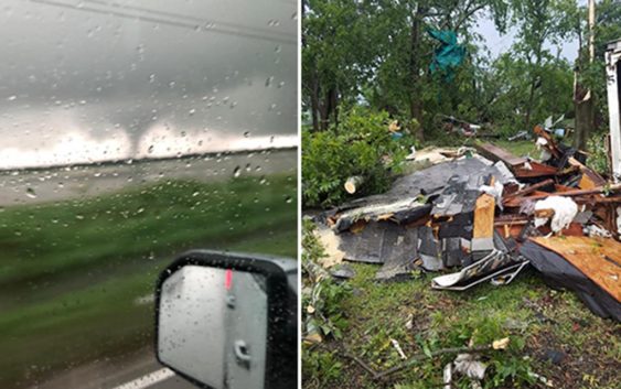
HOUSTON — Tropical Depression Imelda stirred up trouble east of Houston late Wednesday with tornadoes, flash flooding and severe thunderstorms.
Just before 5 p.m., a tornado touched down near Highlands in east Harris County.
Sheriff Ed Gonzalez said his deputies spotted damage to some small structures there, along with tree damage and downed power lines.
There were no reports of injuries.
Gonzalez said there are unconfirmed reports of a small tornado touching down in the Cove area of Chambers County.
The system also brought another round of heavy rain just in time for rush hour headaches.
HIGH WATER LIST: High water locations on major roads across Houston
MAP: Steer clear of these flood-prone spots in Houston
A Flash Flood Watch is in effect for southeast Texas and extreme southwest Louisiana until Thursday morning at 7 a.m.
RELATED: Map: See which Houston streets get the most flooding calls
DOWNLOAD OUR NEW APP: To stay weather aware and get the latest alerts, tap here
WEATHER RADAR: Track rain & storms across Texas
Five ways to prepare for flooding
There are five things you can do right now to make sure you’re ready.
1. Register for AlertHouston
Alert Houston is how the City of Houston sends out critical emergency information. It will alert you via email, text, phone call, or push alert. You can get geo-targeted warnings at your location. You can also register up to five addresses.
2. Register for Harris County’s Flood Warning System
FWS monitors rainfall at more than 250 locations along bayous, creeks, and rivers. It will alert users in real time as water levels rise through email and/or text message.
3. Look at Houston’s Flood Prone Map
The City of Houston Office of Emergency Management partnered with Houston Public Works and TxDOT to identify over 100 flood prone roadways. Drivers should check the map before rain events.
4. Download the Transtar App
The Transtar app allows you to monitor road conditions in real time. It also shows regional alerts and active incidents on an interactive map. (Android users, tap here.)
5. Pay attention to meteorologists
Visit our KHOU Weather page.