- Hurricane survival kit: How to keep your family safe when a hurricane hits
- Houston-area storm damage: Update on status of schools, power outages and resources for storm victims
- EF-1 tornadoes ripped through Cypress, Waller County areas with winds at more than 100 mph, NWS reports
- Houston-area storm damage updates: Clean up continues after NWS says two EF-1 tornadoes and powerful derecho ripped through SE Texas
- Low risk of damaging winds, hail from Saturday storms
Nestor weakens to post-tropical storm cyclone; will bring heavy rain, winds to NC

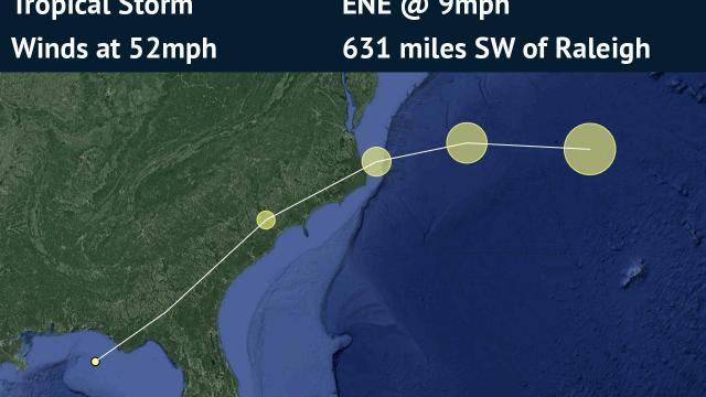
The system named Nestor weakened from a tropical storm to a post-tropical cyclone as it approached Florida on Saturday morning, the National Hurricane Center said.
Storm surge and gusty winds are still expected to impact Florida’s coast along the Panhandle.
Nestor was moving northeast at 9 mph with sustained winds reaching 50 mph on Saturday.
Once Nestor hits land, it will continue to weaken, the National Hurricane Center said. It’s forecast to continue moving northeast and hit North Carolina on Saturday evening.
Rain is expected to hit Fayetteville around 5 p.m. and then Wake County around 6 p.m., WRAL meteorologist Peta Sheerwood said.
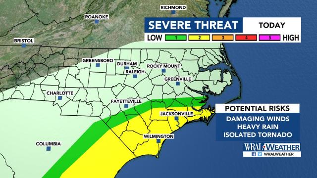
Isolated tornadoes, heavy rain and damaging winds are possible for southeastern parts of North Carolina, which are under a severe weather threat.
Heavier rain will pick up overnight and strengthen early Sunday morning in Durham and Wake counties.
Winds will get gusty on Sunday morning, reaching 36 mph.
Those winds could shut down rides at the State Fair, WRAL meteorologist Aimee Wilmoth said.
The SkyGazer, the 155-foot high ferris wheel new to the NC State Fair this year is designed and manufactured to withstand winds of up to 120 mph winds, but operators said it can only run safely at wind speeds that do not exceed 33 mph.
Although Sunday morning will be soggy, Sheerwood said, conditions will start clearing around noon.
“This weekend is not going to be a complete washout,” Sheerwood said.
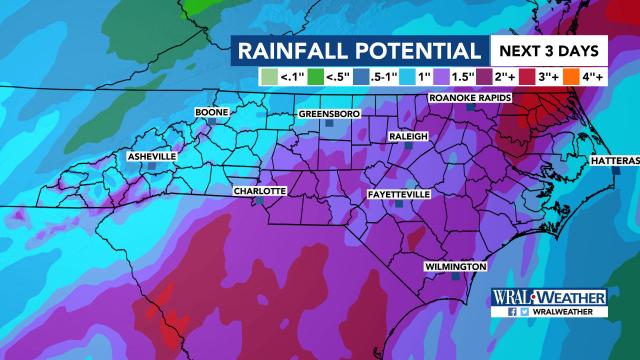
Central North Carolina could see 1 to 3 inches of rain. Northeastern parts of the state could see 4 inches of rain.


