- Hurricane Preparedness Week encourages residents to be ready for what could be an active season
- Some communities in Houston region seeing most rain and flooding since Hurricane Harvey
- Harris County Judge Lina Hidalgo says mandatory evacuation lifted for residents in areas affected by flooding
- Watch Live: Harris County Judge Lina Hidalgo says mandatory evacuation lifted for residents in areas affected by flooding
- Today on Texas Standard: Some Houston regions see the most rain and flooding since Hurricane Harvey
Nestor is Now a Post-Tropical Storm
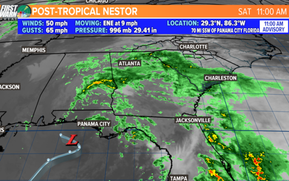
CHARLOTTE, N.C. — For less than 24 hours Tropical Storm Nestor was a “technical” tropical storm but now it has been dubbed Post-Tropical extratropical Nestor. It does not have convection (thunderstorm activity) around the low-level center and satellite imagery indicates that the center has merged with a nearby frontal system making this a standard mid-latitude cyclone (low with a warm and cold front).

WCNC
The merging with another system is where you have heard the term Frankenstorm from Brad Panovich. Superstorm Sandy coined a similar term BUT Nestor is far less severe.
What Now and Does This Affect Charlotte?
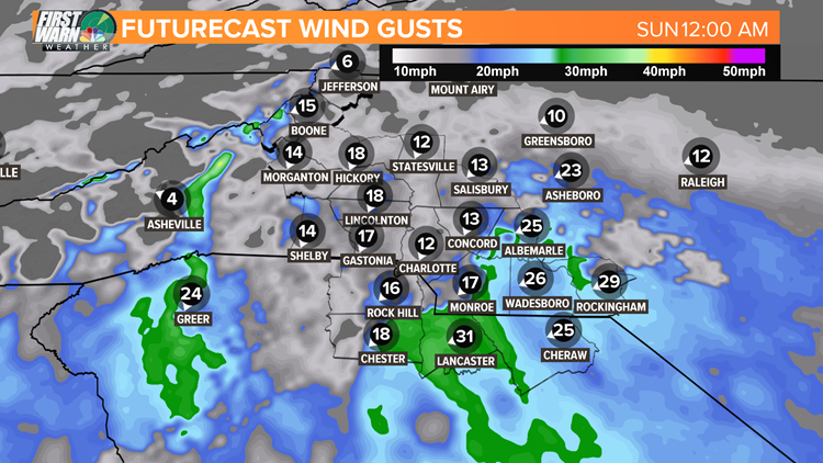
Rain. We will mainly get rain and winds up to 25-35 mph tonight. Rain will be heavy at times and will be persistent!
HOW MUCH: The Charlotte area will likely see up to 1-2″ of rain. Rain totals across the area are going to depend on where the isolated areas of heavy rain end up as this system cruises to the northeast. A general range of 1-3″ is likely with the minority seeing less than an inch and more than 3″.
This type of rain is excellent news for the current drought across the Carolinas!
WINDS: The strongest winds associated with Post-Tropical Storm Nestor will mainly range from 15-30 mph gusts late evening to early morning. The max gusts may be a stray one or two up to 35-40 mph for areas south and east of Charlotte overnight. This will not be a major wind event here!
WCNC WEATHER
RELATED: Tropical system heading to Gulf States
RELATED: Scientists say hurricanes can trigger ‘stormquakes’ on the ocean floor