- EF-1 tornadoes ripped through Cypress, Waller County areas with winds at more than 100 mph, NWS reports
- Houston-area storm damage updates: Clean up continues after NWS says two EF-1 tornadoes and powerful derecho ripped through SE Texas
- Low risk of damaging winds, hail from Saturday storms
- EF 1 tornadoes ripped through Cypress, Waller County areas at more than 100 mph, NWS reports
- Caddo Mounds State Historic Site to celebrate new visitor center, traditional grass house after 2019 tornado
Tropical Storm Nestor to drop 2-4 inches of rain on Wilmington area
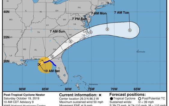
The storm currently as 50 mph sustained winds as it prepares to make landfall near Florida, as of 11 a.m. Saturday.
WILMINGTON — Hours after it makes landfall along the Florida coast, Tropical Storm Nestor is forecast to bring 2-4 inches of rain to the Cape Fear region starting late Saturday afternoon.
The system, which developed into the 2019 hurricane season’s 14th named storm on Friday, began to lose its tropical features as it inched closer to making landfall Saturday morning with 50 mph sustained winds.
The storm had diminished slightly in strength overnight from Friday’s 60 mph winds. But it also slowed down dramatically to 9 mph, as of 11 a.m. Saturday.
Dave Loewenthal, a forecaster with National Weather Service’s Wilmington office, said conditions in Southeastern North Carolina will begin to deteriorate late Saturday and reach their peak severity between midnight and 8 a.m. Sunday. During that window, the region could see the up to 40 mph gusts and an isolated threat of tornados.
“The rain will be heaviest overnight,” he said.
But by mid-morning Sunday, Loewenthal said conditions will rapidly improve as Nestor makes his way northeast, picking up speed along the way.
The forecasted rain will be good news for the region’s borderline drought status. Currently, it is 11 inches below average for the year, according to the NWS Wilmington office.
“Despite Hurricane Dorian, we are still behind in rainfall, so this will certainly help,” Loewenthal said.
But even with the ground in desperate need of water, Loewenthal said there is still the isolated chance for flash flooding as Nestor moves through the region.
Reporter Hunter Ingram can be reached at 910-343-2327 or Hunter.Ingram@StarNewsOnline.com.