- WATCH: Video Shows Confirmed Tornado touches down in Columbus County
- Residents begin clean up after storms, apparent tornado roll through NC Tuesday
- Flooding lingers in Liberty County neighborhoods near Trinity River with more rainfall expected
- North Carolina behind on hurricane preparedness, study shows
- North Carolina way behind on hurricane preparedness, study shows
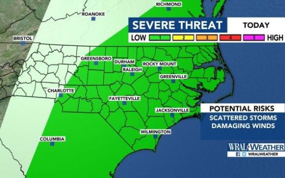
Severe weather risk decreases for Triangle, strong winds and isolated tornadoes still possible
Raleigh, N.C. — Scattered, light rain in the Triangle could get heavier throughout the afternoon as a line of storms that brought tornadoes and heavy rain to Dallas, Arkansas and Oklahoma moves east.
According to WRAL meteorologist Elizabeth Gardner, the line of storms has become more patchy as it moves east. At 12 p.m., the level 2, or moderate, risk for severe weather was downgraded to a level 1 risk.
Subscribe to receive WRAL severe weather alerts to your device
Gardner said more rain and storms could start moving into the region by 2 p.m., peaking around 5 or 6 p.m.
“It gets worse for us as we get into the afternoon,” Gardner said. “That’s when we’ll have a better chance of some of those stronger thunderstorms.”
Those going to the State Fair on Tuesday may want to leave after lunchtime, Gardner said.
Fair officials said they transmit any weather warnings through loudspeakers and will usher people to safe places on the fairgrounds.

By 8 p.m., any severe weather should be moving out of the area.
The severe weather could bring 50 to 60 mph winds to the region — strong enough to bring down branches and small trees. An isolated tornado is possible, but that threat is slim, Gardner said. Flooding should not be an issue.

Behind the storms is a cold front that will bring much cooler air to the region on Wednesday. Overnight, temperatures will be chilly, in the upper 40s, and Wednesday’s high is only 67 degrees in Raleigh.
Wednesday and Thursday will both be dry days for fairgoers.
A chance for rain returns for Friday and the weekend, but the timing of the rain isn’t certain, Gardner said.
