- Seven months after Hurricane Helene, Chimney Rock rebuilds with resilience
- Wildfire in New Jersey Pine Barrens expected to grow before it’s contained, officials say
- Storm damage forces recovery efforts in Lancaster, Chester counties
- Evacuation orders lifted as fast-moving New Jersey wildfire burns
- Heartbreak for NC resident as wildfire reduces lifetime home to ashes
Tornado watch canceled for most of NC, including the Triangle
A tornado watch is in effect for central North Carolina as a dangerous line of storms threatens the region. Hundreds of thousands are without power in the state.
“Please, if you don’t have to be out in the morning, don’t go to the grocery store, don’t go to the pharmacy, because it’s not going to be safe to be out and about between about 5 a.m. to 11 a.m.,” said WRAL meteorologist Mike Maze. “Stay home and turn on WRAL, we want you to be safe.”
Download the WRAL Weather app for alerts on your mobile device
The entire viewing area is under a level 3, or enhanced, threat Monday morning, which means tornadoes and storms are widespread.
Things to know:
- A tornado watch has been canceled for most of North Carolina, including the Triangle.
- A wind advisory is in effect until 4 p.m. Wet grounds and strong winds could bring down trees and cause power outages all day. All weather alerts.
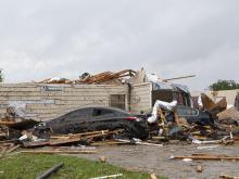
- Twelve counties in our viewing area have seen tornado warnings come and go throughout the morning.
- Tornadoes have touched down in western Orange County close to Hillsborough and in Alamance County south of Graham.
- Multiple trees have fallen on homes, and a 12-year-old boy was taken to the hospital after a tree fell on him.
- A car became submerged in floodwaters water in Roxboro.
Latest on severe weather:
8:00 a.m.: The threat of storms has ended for counties west of Raleigh and for most of the Triangle, though strong winds mean trees can fall throughout the day. Eastern counties will continue seeing some storms throughout the morning.
7:55 a.m.: While a tornado warning was not issued for the area, some rotation was detected east of I-40 in Johnston County. Smithfield and Clayton will likely be missed, but Wilson’s Mills and Four Oaks have the potential for some wind damage.
7:45 a.m.: A power pole snapped on Ode Turner Road in Hillsborough. A severe thunderstorm warning was issued for Wake County, and tornado warnings were issued for Vance and Warren counties.
7:40 a.m.: The tornado warnings in Hoke, Cumberland, Harnett and Moore counties have been canceled.
7:35 a.m.: WRAL News received a report of a tree on a house on Hawkins Avenue in Sanford, where a child was injured and taken to the hospital. Another tree fell on a home on Rives Chapel Church Road in Siler City.
7:30 a.m.: Isolated flooding was reported in Roxboro, where a car became trapped in floodwaters. No severe thunderstorm warnings have been issued for the Triangle yet, and no tornadoes appear to be forming here, Elizabeth Gardner said. The threat, however, is not over, and people should stay home and watch the weather.
7:25 a.m.: Hoke, Cumberland, Harnett and Moore counties are included in a new tornado warning until 7:45 a.m. Areas around Southern Pines have already seen the worst of the storms.
7:20 a.m.: A tornado warning in Granville County has expired. About 160,000 in North Carolina are without power, the majority west of the Triangle.
7:15 a.m.: CNN is reporting at least 13 people have died in storms in the South, including someone in Oconee County, South Carolina.
7:10 a.m.: A tornado hit in southeast Alamance County, WXII reports. The tornado was first spotted 10 miles south of Graham, moving in a northeast direction. Velocity speeds of 50-60 miles per hour were reported.
7:05 a.m.: The most severe storms should impact the Triangle soon. Reports of 60 mph winds have been reported west of the Triangle.
7:00 a.m.: Hoke, Lee, Moore, Harnett and Cumberland counties are now under severe thunderstorm warnings. A thunderstorm will likely be issued for Wake and Durham counties soon.
6:55 a.m.: The main tornado threat has moved out of Person County and into Granville County. The tornado threat has lessened in Hillsborough and the warning is about to expire. Heavy rain is starting to move into Raleigh.
6:50 a.m.: The tornado warnings in Durham and Alamance counties have expired.
6:45 a.m.: Tornado warnings are in effect for Person and Granville counties until 7:15 a.m. A tornado is on the ground just east of the Saxapahaw area. People in that area need to take shelter immediately.
6:40 a.m.: Tornado damage and debris is showing up on the radar south of Swepsonville, a town in Alamance County.
6:30 a.m.: Mebane is reporting that a tornado touched down. A tornado warning has been issued for parts of Durham and Chapel Hill and is in effect until 7 a.m.
6:20 a.m.: A tornado warning in effect for northern Orange County, which includes Hillsborough.
6:15 a.m.: A tree fell on Glenwood Avenue at T.W. Alexander Drive, blocking one lane. More than 100,000 customers in North Carolina are now without power, and hundreds of those outages are in Raleigh and Durham.
6:00 a.m.: A tornado warning has been issued for Yanceyville near the edge of Person County. WRAL meteorologist Elizabeth Gardner said storms will pass over downtown Raleigh shortly.
5:45 a.m.: A tornado warning is in effect for parts of Alamance and Chatham counties until 6:15 a.m. The rotation was moving northwest very quickly at 60 mph. Large hail and strong winds as fast as 60 mph are likely.
5:30 a.m.: More than 1,000 have now lost power in the Triangle as strong winds and storms move closer to Raleigh.
5:00 a.m.: Around 64,000 customers had already lost power west of the Triangle. Winston Salem reported trees down and storm damage after a tornado warning was issued for the area, and UNC Greensboro tweeted out a warning to students.

Timing and threats
Timing — A strong line of thunderstorms will slowly cross the region Monday morning. Storms were in central North Carolina by 5 a.m. and could arrive in Durham and other western counties by 6 or 7 a.m. By 7 or 8 a.m., the storms will be headed for Raleigh and Fayetteville. At 9 a.m., Raleigh could be right in the middle of the storm. Conditions will improve by 10 or 11 a.m.

Tornadoes and more threats — The areas shaded in yellow have a 10% chance for strong tornadoes, EF-2 or greater. In the event of a tornado warning in your area, seek shelter in an interior room — a closet, a pantry, a bathroom — with no windows.

Widespread, damaging wind gusts are possible, with gusts ranging between 20-30 mph with the potential to reach 70 mph or greater at times.
Golf ball-sized hail is possible.
As much as an inch of rain will fall Monday morning, creating the possibility for isolated flooding. Even after the storms move out, soaked roots and soil could produce some downed trees.

Power outages could be widespread through Monday afternoon.
“This system will move out in the early afternoon, but windy conditions continue through the evening,” Maze said. The National Weather Service has posted a high wind advisory for much of the state, including Cumberland, Durham and Wake counties from 4 a.m. through 4 p.m. Monday.

Prepare for a power outage
Gov. Roy Cooper sent out a press release Sunday afternoon urging North Carolinians to prepare for power outages and severe weather overnight.
People were encouraged to turn on weather radios or charge their devices before bedtime to make sure they can receive weather alerts in the middle of the night. Make sure your household knows where to gather to shelter in place if a tornado warning is issued. Keep batteries and flashlights handy and know how to report an outage to your power company. Sign up for WeatherCall.
The stay-at-home order will make grocery shopping more difficult once the severe weather is over. Prepare for power outages by having a cooler and ice ready to store refrigerated or perishable foods.

Food will stay frozen for 36 to 48 hours in a fully loaded freezer if you keep the door closed. A half-full freezer will generally keep food frozen for 24 hours.
If you lose power, notify the utility company right away, officials said. Don’t rely on your neighbors to do it for you.