- Houston-area storm damage: Update on status of schools, power outages and resources for storm victims
- EF-1 tornadoes ripped through Cypress, Waller County areas with winds at more than 100 mph, NWS reports
- Houston-area storm damage updates: Clean up continues after NWS says two EF-1 tornadoes and powerful derecho ripped through SE Texas
- Low risk of damaging winds, hail from Saturday storms
- EF 1 tornadoes ripped through Cypress, Waller County areas at more than 100 mph, NWS reports
NC Weather: Tropical Storm Arthur is about 50 miles off the North Carolina coast
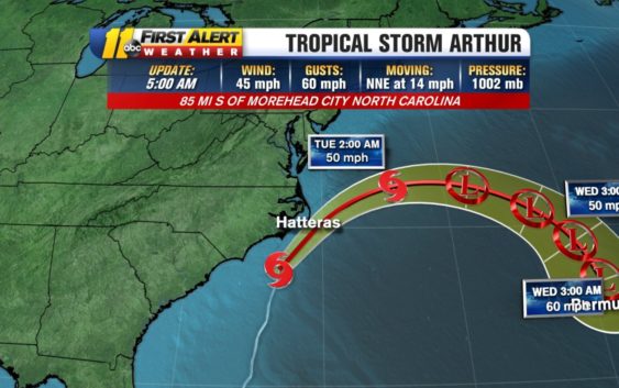
RALEIGH (WTVD) — Rain continues to spread inland as Tropical Storm Arthur makes its final approach toward the Outer Banks.
A Tropical Storm Warning is in effect from near Surf City up to the North Carolina-Virginia border. A Tropical Storm Warning means sustain winds could be between 39 and 73 miles per hour.
The most recent update from the National Hurricane Center found Arthur’s sustained winds were at 40 miles per hour.
At 8 a.m., Arthur was located 50 miles east southeast of Morehead City and 50 miles south southwest of Cape Hatteras. They system is traveling at approximately 15 miles per hour.
The storm is expected to lose its tropical characteristics some time Tuesday–by then it will have turned east and started moving away from the United States.
While Arthur is expected to stay off the coast, rain bands from the storm have already made it onshore.
The heaviest of the rain will happen east of Interstate 95 between 9 a.m. and 12 p.m.
All of the rain will have moved off the coast by 3 p.m., and temperatures will remain in the 70s due to cloud cover.
The quick-moving storm could drop between 1-2 inches of rain–with the highest amounts near the coast.
With systems like Arthur, the storm surge can still pose a significant threat, especially inland. But in this case, ABC11’s Don “Big Weather” Schwenneker is not expecting major storm surge problems.
The Pamlico Sound and Neuse River could see up to 7-foot storm surges. Hatteras down to Ocracoke could see up to a 5-foot storm surge. But with larger systems, the storm surge can easily reach 10-12 feet.
Regardless of whether this storm makes landfall or not, we will see heavy rainfall, mainly east of I-95 where a total of 1 to 2 inches of rain may fall by early this afternoon, with higher amounts near the coast.
Rain will taper off this afternoon and evening from south to north with a brief window for dry weather this evening.
Breezy conditions will be found across the Triangle this morning, then winds begin to diminish into this afternoon as Arthur pulls away from the coast.
Copyright © 2020 WTVD-TV. All Rights Reserved.