- Severe weather leads to fallen trees, car crashes and flooding around the Triangle
- New video shows vehicles being swept away in historic, deadly flash floods in SA on June 12
- $40 million to go to underserved SC counties for Hurricane Helene recovery. Here's what you need to know.
- Family honors Air Force veteran Derwin Anderson Jr. after he died in June flash floods
- City of Wilmington addresses flooding on New Centre Drive
Tropical Storm Arthur hits Outer Banks with storm surge, rip currents and heavy rain
Carolina Beach, N.C. — The heaviest impacts from Tropical Storm Arthur will hit North Carolina’s coast Monday morning.
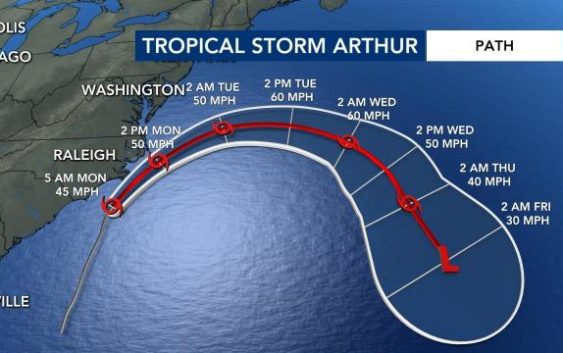
The 5 a.m. update from the National Hurricane Center showed Arthur was 135 miles south of Cape Hatteras. The latest track shows the storm is heading northeast toward the Outer Banks at 14 miles per hour with maximum sustained winds at 45 mph and gusts of 60 mph.
WRAL meteorologist Elizabeth Gardner said much of the rain from the storm has already passed Wilmington, and the Outer Banks will see the worst of Arthur around 8 a.m., when the storm makes its closest pass to the coast.
The system will stay offshore, and it is not expected to impact the Triangle.
Gardner said the Outer Banks could see impacts from Arthur through noon before the storm pushes out to the east. “By 8 p.m., the storm will be out of here,” she said.

The biggest impacts from Arthur will be heavy rain, winds and high waves. Large waves were already pounding the shore at Carolina Beach overnight, but the worst impacts are expected at the Outer Banks as Arthur moves northeast. The Outer Banks can expect one to four inches of rain.
Gardner said homes should not be damaged by the storm, but beach erosion could occur. Swimmers and surfers should avoid the ocean Monday.
Carolina Beach Ocean Rescue Captain Tony Wallace said, despite coronavirus social distancing guidelines, officials made the decision to put a small number of lifeguards on the beach over the weekend.

A tropical storm warning has been issued for the North Carolina coast from Surf City to Duck, NC, Pamlico and Albemarle Sounds. Storm surge is possible up to two feet high in these areas. See which counties are under a tropical storm warning
The Triangle should not be impacted by Arthur, but we will see impacts from the cold front that will cause Arthur to turn east and move back out to the Atlantic. The Triangle could see rain Monday night that will last through much of the work week.
This is the sixth year in a row a system formed earlier than hurricane season, which officially begins June 1.