- Very large hail, tornado threat returns to Texas amid severe storm risk
- Habitat for Humanity helping Rock Hill residents assess, clean up storm damage. They are also seeking volunteers
- Smokehouse Creek wildfire victims line up lawsuits against utility
- Will Mexico wildfires impact Houston's air quality?
- The worst tornadoes in North Carolina History
Tropical Storm Arthur 'has degraded significantly' as rains begin to hit NC coast
N.C. — Tropical Storm Arthur’s outer rain bands have reached the North Carolina shore, but the storm appears to be getting weaker.
According to the National Hurricane Center’s 11 p.m. update Sunday, “Arthur’s appearance in radar and satellite imagery has degraded significantly since the 5 p.m. advisory with very little rain band features present now.”
The latest track shows the storm is heading north northeast toward the North Carolina coast at 10 miles per hour with maximum sustained winds at 45 mph and gusts of 60 mph.
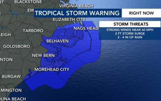
The updated trajectory shows the storm is 175 miles from Morehead City and 210 miles south of Cape Hatteras.
“The storm will impact the coast the worst from 5 a.m. (Monday) near Morehead City to roughly 6 p.m. near Nags Head. The center of circulation looks to stay just off shore,” said WRAL meteorologist Zach Maloch.
A tropical storm warning has been issued for the North Carolina coast from Surf City to Duck, NC, Pamlico and Albemarle Sounds.Storm surge is possible up to two feet high in these areas.
“The greatest wind threat will be for the Outer Banks due being in an area with a lot of water, which means very little friction can weaken wind gusts,” Maloch said.
To check a full list of what counties are under a tropical storm warning, check here.
The Outer Banks can expect one to four inches of rain.
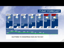
Maloch does not expect the Triangle to see impacts from Arthur, “However, we will see impacts from the cold front / low pressure trough that is causing Arthur to turn right (east) and move back out to the Atlantic. Impacts will be a lot of rain arriving Monday late night that will last through much of the work week ahead,” he said, noting the Triangle could see 1 to 2.5 inches of rain from Monday to Friday morning.
This is the sixth year in a row a system formed earlier than hurricane season, which officially begins June 1.

Approaching cold front could also bring rain
A cold front that will come in and push the high-pressure tropical storm to the east could also bring some rain to North Carolina on Monday and Tuesday, WRAL meteorologist Elizabeth Gardner said.
Because of that front, plan to see some cooler temperatures when the cold front does come in.
Even though the tropical storm is moving north, we will keep the warm weather in place this weekend.