LIVE BLOG: Hail, wind damage left behind by storms

LIVE BLOG: Hail, wind damage left behind by storms

CHARLOTTE, N.C. — This is a severe weather live blog from WCNC Charlotte: 7:15 p.m.: Early storm reports indicate the storm produced damaging hail, upward of 1.5″ – 2″ inch, and produced winds strong enough to topple trees. If you have storm pictures or videos, you can text them to us at 704-329-3600. You can also reach us on Facebook and Twitter. 7:00 p.m.: The National Weather Service has extended the Tornado Warning into Lancaster County until…

Read More

LIVE BLOG: Tornado Warning for Lancaster County, South Carolina

LIVE BLOG: Tornado Warning for Lancaster County, South Carolina

CHARLOTTE, N.C. — This is a severe weather live blog from WCNC Charlotte: 7:15 p.m.: Early storm reports indicate the storm produced damaging hail, upward of 1.5″ – 2″ inch, and produced winds strong enough to topple trees. If you have storm pictures or videos, you can text them to us at 704-329-3600. You can also reach us on Facebook and Twitter. 7:00 p.m.: The National Weather Service has extended the Tornado Warning into Lancaster County until…

Read More

LIVE BLOG: Tornado Warning for Chester, Lancaster counties in South Carolina

LIVE BLOG: Tornado Warning for Chester, Lancaster counties in South Carolina

CHARLOTTE, N.C. — This is a severe weather live blog from WCNC Charlotte: 7:00 p.m.: The National Weather Service has extended the Tornado Warning into Lancaster County until 7:30 p.m. Locations inside the extended warning include, but are not limited to, Heath Springs, Kershaw, and Westville. At 7 p.m., the tornado was crossing out of Chester County over the Catawba River. The warning for Chester County continues until 7:15 p.m. 6:30 p.m.: The National Weather Service…

Read More

LIVE BLOG: Tornado Warning for Chester County, South Carolina

LIVE BLOG: Tornado Warning for Chester County, South Carolina

CHARLOTTE, N.C. — This is a severe weather live blog from WCNC Charlotte: 7:00 p.m.: The National Weather Service has extended the Tornado Warning into Lancaster County until 7:30 p.m. Locations inside the extended warning include, but are not limited to, Heath Springs, Kershaw, and Westville. At 7 p.m., the tornado was crossing out of Chester County over the Catawba River. The warning for Chester County continues until 7:15 p.m. — 6:30 p.m.: The National Weather…

Read More

WEATHER MINDS CLASSROOM: Hurricane structure and steering

WEATHER MINDS CLASSROOM: Hurricane structure and steering

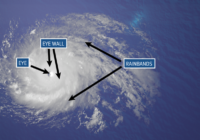
SAN ANTONIO — Hurricane season is less than a month away and on this edition of ‘Cloudy with a Chance of Learning’ we talked about hurricane structure and what steers the storms. The structure of a hurricane can tell us a lot about the health of the storm. If a storm is strong and healthy, it will often have a well-defined eye. Other features that hurricanes have can be seen from satellite imagery. A strong…

Read More

Severe weather possible tonight in Charlotte, across Carolinas

Severe weather possible tonight in Charlotte, across Carolinas

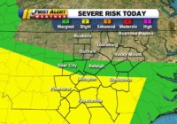
CHARLOTTE, N.C. — A low end risk for severe weather Tuesday night could producing strong-to-severe thunderstorms capable of damaging wind, hail, and an isolated tornado. Starting around 7 p.m. and continuing through 10 p.m., the main line of thunderstorms is expected to push across Charlotte, Mecklenburg County, and the surrounding metro. Additional discrete, scattered thunderstorms outside of that timeperiod cannot be ruled out. A Severe Thunderstorm Watch was in effect for our entire area through…

Read More

Severe weather possible tonight

Severe weather possible tonight

CHARLOTTE, N.C. — A low end risk for severe weather Tuesday night could producing strong-to-severe thunderstorms capable of damaging wind, hail, and an isolated tornado. Starting around 7 p.m. and continuing through 10 p.m., the main line of thunderstorms is expected to push across Charlotte, Mecklenburg County, and the surrounding metro. Additional discrete, scattered thunderstorms outside of that timeperiod cannot be ruled out. A Severe Thunderstorm Watch was in effect for our entire area through…

Read More

Gusty winds, hail are main threat in Tuesday night severe weather across central NC

Gusty winds, hail are main threat in Tuesday night severe weather across central NC

RALEIGH, N.C. (WTVD) — Parts of central North Carolina are under marginal risk for severe weather Tuesday evening. Areas south of the Triangle are under a Level 2 risk, while the Triangle and areas further north are under a lower risk. A cluster of storms will move across central North Carolina between 7 and 11 p.m. Areas south of the Triangle could see damaging wind gusts and large hail. What are straight-line winds and how…

Read More

Tornadoes, large hail possible with storms across southern part of NC tonight

Tornadoes, large hail possible with storms across southern part of NC tonight

By Mike Maze, WRAL meteorologist Raleigh, N.C. — A level 2 threat for severe weather in our southern counties could bring the Triangle some rain and storms on Tuesday evening, according to WRAL meteorologist Mike Maze. There is a level 1 risk for severe weather in parts of the Triangle and a level 2 risk in some areas southwest of the Triangle, including Sanford, Goldsboro, Fayetteville and Lumberton. “We have a warm front moving into…

Read More

Severe weather threat increases for Triangle, will be worse in southern counties

Severe weather threat increases for Triangle, will be worse in southern counties

Raleigh, N.C. — A level 2 threat for severe weather in our southern counties could bring the Triangle some rain and storms on Tuesday evening, according to WRAL meteorologist Elizabeth Gardner. Across central North Carolina, conditions will stay cool and cloudy for much of the day, with highs in the 50s to lower 60s. There is a level 1 risk for severe weather in parts of the Triangle and a level 2 risk in some…

Read More

Brunswick County gets funding to repair EMS facility damaged in Florence

Brunswick County gets funding to repair EMS facility damaged in Florence

Share on Facebook Tweet on Twitter Some cars risked their luck and drove through the flooded highway in Brunswick County. (Photo: WWAY) NORTH CAROLINA (WWAY) — The State of North Carolina and FEMA continue to support a wide variety of Hurricanes Florence recovery projects throughout the state. The following organizations are recent beneficiaries of state and federal dollars that reimburse expenses related to the storms. Brunswick County: more than $9,200 to repair an EMS facility…

Read More

All Hail Andy Dalton! The Most Important Opponent in Texans History

All Hail Andy Dalton! The Most Important Opponent in Texans History

On Saturday evening, news broke that the Dallas Cowboys had signed free agent quarterback Andy Dalton. Dalton, a Katy native, had not been a free agent all that long, having been released by the Cincinnati Bengals on Thursday morning after a nine year run that saw him lead the Bengals to five playoff appearances, but no playoff victories. It’s a good signing by the Cowboys, who immediately become a team that could make some noise,…

Read More

Port Aransas Sees Thousands Of Visitors As Texas Stay-At-Home Orders Relax Amid Pandemic

Port Aransas Sees Thousands Of Visitors As Texas Stay-At-Home Orders Relax Amid Pandemic

A steady stream of cars, trucks and golf carts drove along the sand of Port Aransas’ beaches on Saturday morning. Along the water, beachgoers set up canopies and chairs. After  Gov. Greg Abbott’s stay-at-home order expired last week, many stir-crazy Texans flocked to the popular Gulf Coast tourist destination. While the beaches were packed, visitors and locals had mixed feelings about the city’s tourism industry rebooting as COVID-19 cases continue to rise.  Jason Arredondo and…

Read More
1 18 19 20 21