- $40 million to go to underserved SC counties for Hurricane Helene recovery. Here's what you need to know.
- Family honors Air Force veteran Derwin Anderson Jr. after he died in June flash floods
- City of Wilmington addresses flooding on New Centre Drive
- Harnett County fire: Two homes damaged
- Medical examiner identifies 13th victim from massive flash flood in San Antonio
Hurricane Isaias track shifts west, could hit Florida as Cat. 1 storm Saturday

Raleigh, N.C. — Hurricane Isaias could hit Florida Saturday as a Category 1 storm before weakening and heading for the Carolinas.
Resources: Interactive Hurricane Tracker | Coastal Webcams | Get WRAL alerts during severe weather | Know your flood risk
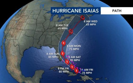
The 11 a.m. advisory from the National Hurricane Center shows that Hurricane Isaias has weakened just slightly with maximum sustained winds at 75 mph. Isaias’ forecast track has shifted to the west, indicating the storm could hit Florida early Saturday as a Category 1 hurricane.
The American model shows Isaias brushing or hitting the North Carolina coast as a Cat. 1 storm Monday before weakening to a tropical storm Tuesday morning.
A tropical storm watch is in effect for parts of the Florida coast. There is a risk for storm surges, heavy rain and winds along the Florida coast this weekend.
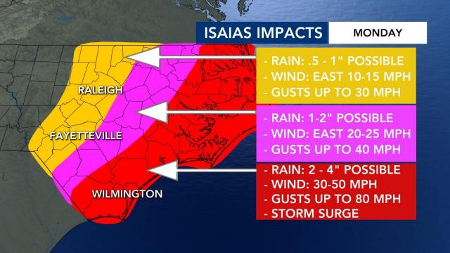
North Carolina impacts expected Monday
Much of the North Carolina coast is under a moderate to high rip current risk throughout the weekend, but other effects from Isaias won’t be felt until Monday.
Isaias is expected to stay a Cat. 1 hurricane as it nears our coast Monday with winds between 75-80 mph.
WRAL meteorologist Zach Maloch said the storm’s eyewall could brush Wilmington and possibly the Outer Banks sometime Monday afternoon.
There is a high threat for rip currents along the North Carolina from Wilmington to Ocracoke Island starting Friday. A moderate rip current threat will be in effect north of Ocracoke Island and south of Wilmington.
This weekend, the coast could experience a few afternoon storms. By Monday, tropical storm or hurricane conditions are more likely. Periods of heavy rain and weak tornadoes will be possible along the coast as Isaias rain bands move in. Since parts of eastern North Carolina have had heavy rain over the last couple of weeks, trees are likely to come down, and power outages are possible.
The Triangle will mostly see scattered thunderstorms and periods of heavy rain. If Isaias tracks more to the east and stays offshore, those impacts will be less. If it tracks to the west, the Triangle will be more impacted.
“The bottom line? North Carolina will have impacts from this storm,” said WRAL meteorologist Aimee Wilmoth. “What exactly those impacts will be depends on what happens as this storm nears Florida. For now, we need to prepare for a Cat. 1 hurricane to move into our southern coast Monday afternoon. Inland impacts are almost impossible to know at this point.”
Isaias impacting the Bahamas
On Thursday while still a tropical storm, Isaias knocked out power, toppled trees and caused widespread flooding and small landslides in the Dominican Republic and Puerto Rico, where at least 35 people were rescued from floodwaters and one person remained missing. A hurricane warning was in effect for the northwestern Bahamas, including Andros Island, New Providence, Eleuthera, Abaco Islands, Berry Islands, Grand Bahama and Bimini.
Isaias is the earliest “I-named storm” on record.


