- “We lost everything”: East Texas residents confront their future after flooding
- Conroe police officer critically injured in Trinity County tornado dies
- Flood risk and severe weather threat for Central Texas over the weekend
- ‘Hasn’t been this bad since Harvey': Woodloch residents in Montgomery County brace for more flooding
- Fire & emergency leaders prepare for another wildfire season in Central Texas
Hurricane Isaias weakens slightly, shifts westward on its track toward North Carolina
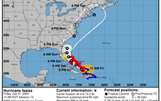
RALEIGH (WTVD) — Hurricane Isaias continues to track toward the east coast and most projections have the storm impacting the southeastern United States, including North Carolina, in the coming days.
Friday’s 11 a.m. update showed the storm track shifted slightly west. The overall storm is slightly slower and weaker than earlier projections. Isaias could graze Florida for much of the day Saturday and Sunday morning.
Hurricane Isaias’ maximum sustained winds dropped from 80 miles per hour to 75 miles per hour. Its gusts dropped from 100 miles per hour to 90 miles per hour.
Because of that decrease in strength, ABC11 Meteorologist Robert Johnson said it is unlikely that the storm will reach Category Two strength as it was briefly forecasted to do.
The storm has battled windshear, which has made it tough for the storm to strengthen. Likewise it has not had a clearly defined eye, making it more difficult to forecast.
Storm Ready 2020: Preparing in a Pandemic
On Friday morning, the storm was spinning around Turks & Caicos and dumping heavy rain on the Bahamas. The National Hurricane Center said flash-flooding and mudslides are possible across the Dominican Republic, northern Haiti, Turks & Caicos and the Bahamas.
On Thursday, more than 400,000 customers in Puerto Rico lost power, according to ABC News. Some were trapped in flooding.
While that path is still a long way out and could change drastically, at this time it does look like Isaias will at least bring rain to parts of North Carolina next week.
However, the coast is already seeing effects of Isaias as a high risk rip current goes into effect starting Friday stretching from Hatteras down to Carolina Beach. The elevated threat will go on into the weekend as the storm continues to move north.
Colorado State University hurricane researcher Phil Klotzbach said Isaias is the earliest ninth Atlantic named storm. The previous record was Irene on August 7, 2005.
The storm’s cone of uncertainty does include North Carolina. Current projections say the storm will reach our shores Monday night into Tuesday morning.
Stay with the ABC11 First Alert Weather team as they monitor this hurricane and any threats it may bring to North Carolina.
Also, while Isaias is the only named tropical storm in the Atlantic right now, the National Hurricane Center is monitoring two other systems that may soon develop.
The system in the middle of the Atlantic might develop into a tropical system sometime next week. However, the system that just formed off the coast of Africa is expected to become a tropical depression later today.
NHC is monitoring two other disturbances this morning, both over the tropical Atlantic Ocean. The system near Africa has a chance to become a tropical depression later today, while the system near 45W could slowly develop over the SW Atlantic next week. https://t.co/tW4KeFW0gB pic.twitter.com/DDFhc9kiDr
— National Hurricane Center (@NHC_Atlantic) July 31, 2020
WATCH: Big Weather’s hurricane emergency kit
Copyright © 2020 WTVD-TV. All Rights Reserved.