- How to protect your car before a hailstorm
- ‘We lost everything’: East Texas residents confront their future after flooding
- Here's how to get your flooding debris picked up by the City of Houston
- Mosquito activity on the rise due to rainfall, flooding across Texas
- Volunteers help Conroe community clean up in wake of flooding in Montgomery County
Tracking Hurricane Isaias: 2 p.m. Saturday update
The latest information on the projected path of Hurricane Isaias
As of 11 a.m. Saturday, Hurricane Isaias was making landfall on the Northern Andros Island and is expected to approach the southeast coast of Florida later in the day.
The storm is still moving northwest near 12 mph. A general northwestward motion with some decrease in forward speed is expected for the next day, followed by a north-northwestward motion motion by late Sunday, according to the latest update from the National Hurricane Center.
Maximum sustained winds have decreased to 80 mph with higher gusts. Little change in strength is expected through Sunday. Slow weakening is expected to begin by late Monday.
Hurricane-force winds now only extend outward up to 25 miles from the center and tropical-storm-force winds extend outward up to 115 miles, both a decrease of 10 mph from the 8 a.m. update.
Reports from a U.S. Navy site on Andros Island indicate that sustained winds of 45 mph and a gust of 69 mph occurred around 8 a.m. A sustained wind of 35 mph and gust of 48 mph were measured at Nassau, Bahamas.
Coastal North Carolina remains likely to experience heavy surf and rip currents through the weekend. Tropical storm force winds could reach the area by late Sunday into early Monday morning.
The next update from the National Hurricane Center will be at 2 p.m. Saturday.
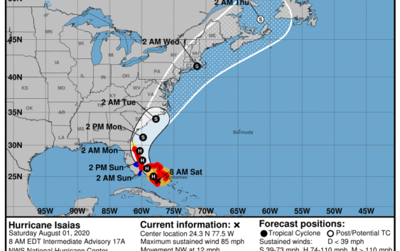
8 a.m. update
As of 8 a.m. Saturday, Hurricane Isaias was churning in the Caribbean and bringing heavy rain and winds to the Bahamas.
The storm was moving northwest at about 12 mph, but some decrease in forward speed is expected, according to the latest update from the National Hurricane Center.
A turn toward the north-northwest is expected by late Sunday. Isaias will likely approach the Florida peninsula Saturday night through Sunday.
Maximum sustained winds were recorded near 85 mph with higher gusts. The hurricane center predicts little change in strength through Sunday.
Hurricane-force winds extend outward up to 35 miles from the center and tropical-storm-force winds extend outward up to 175 miles.
Coastal North Carolina is likely to experience heavy surf and rip currents through the weekend. Tropical storm force winds could reach the area by late Sunday into early Monday morning.
The next update from the National Hurricane Center will be at 11 a.m. Saturday.
*****Editor’s Note: Our emergency coverage on Hurricane Isaias is being provided free as a public service to our readers. Please support local journalism by subscribing:
Wilmington StarNews: www.StarNewsOnline.com/subscribenow
New Bern Sun Journal: www.newbernsj.com/subscribenow
Jacksonville Daily News: www.jdnews.com/subscribenow
Kinston Free Press: www.kinston.com/subscribenow