- Flood Watch issued for San Antonio and surrounding areas
- 9-year-old’s heroic act saves parents after Oklahoma tornado: ‘Please don’t die, I will be back’
- Hurricanes beat Islanders to clinch NHL playoff 1st-round series in 5 games
- Drury, Noesen help Hurricanes beat Islanders 6-3 to clinch NHL playoff 1st-round series in 5 games
- Weekend storm damage caused by 2 confirmed tornadoes in Central Texas
Tracking Tropical Storm Isaias: 8 p.m. Saturday update
The latest information on the projected path of Tropical Storm Isaias
As of 5 p.m., Isaias has weakened to a tropical storm, although it is expected to re-strengthen to a hurricane overnight while it approaches the southeast coast of Florida.
According to the National Hurricane Center’s latest update, the storm, with maximum sustained winds of 70 mph, was moving northwest at 10 mph. A general northwestward motion with some decrease in forward speed is expected for the next day, followed by a north and north-northwestward motion by late Sunday and a turn toward the north and north-northeast on Monday and Tuesday with an increase in forward speed.
The forecast track currently shows Isaias approaching the southeast coast of Florida Sunday and Sunday night. On Monday and Tuesday, the center of Isaias will move quickly from offshore of the coast of Georgia into the southern mid-Atlantic states.
Tropical-storm-force winds are extending outward up to 105 mph from the center. A Weatherflow observing site at the Dania Pier in Broward County, Florida, received a wind gust of 59 mph in an outer rainband. A wind gust of 41 mph was recently reported by a Weatherflow site in Juno Beach, Florida.
Isaias is expected to produce 2 to 5 inches of rainfall in the Carolinas, with isolated maximum of 7 inches. Heavy rainfall could result in potentially life-threatening flash flooding in low-lying and poorly drained areas in the Carolinas. Minor river flooding is possible across portions of the Carolinas as well.
The next intermediate advisory will be at 8 p.m.
2 p.m. update
The 2 p.m. update from the National Hurricane Center has Hurricane Isaias emerging over the Straits of Florida with an expected approach to the southeast coast of Florida Saturday night.
There were no major changes in the storm’s movement direction or speed from the 11 a.m. update, still moving northwest near 12 mph with a general northwestward motion and decreased forward speed expected for the next day, followed by a north-northwestward motion by late Sunday.
The center of Isaias will move over the Straits of Florida tonight and approach the southeast coast of Florida early Sunday morning. Isaias is then forecast to move near or along the east coast of the Florida peninsula into Sunday night.
Data from a reconnaissance aircraft and Doppler radar show that maximum sustained winds have decreased to near 75 mph with higher gusts. It is noted that although Isaias has weakened after passing over Andros Island, some re-strengthening is expected over night and Sunday morning when the storm will be moving over warmer waters. Isaias is forecast to remain a hurricane through Monday, followed by slow weakening beginning Monday night or Tuesday.
Hurricane-forced winds are still extending outward up to 25 miles and tropical-storm-force winds up to 115 miles outward. A wind gust of 49 mph was observed at Nassau, Bahamas and tropical-storm-forced winds have been observed just offshore of Broward and Miami-Dade counties.
Isaias is expected to produce 2 to 4 inches of rainfall in the Carolinas, with isolated maximum of 6 inches. Heavy rainfall could result in potentially life-threatening flash flooding in low-lying and poorly drained areas in the Carolinas. Minor river flooding is possible across portions of the Carolinas as well.
The next update from the National Hurricane Center will be at 5 p.m. Saturday.
11 a.m. update
As of 11 a.m. Saturday, Hurricane Isaias was making landfall on the Northern Andros Island and is expected to approach the southeast coast of Florida later in the day.
The storm is still moving northwest near 12 mph. A general northwestward motion with some decrease in forward speed is expected for the next day, followed by a north-northwestward motion motion by late Sunday, according to the latest update from the National Hurricane Center.
Maximum sustained winds have decreased to 80 mph with higher gusts. Little change in strength is expected through Sunday. Slow weakening is expected to begin by late Monday.
Hurricane-force winds now only extend outward up to 25 miles from the center and tropical-storm-force winds extend outward up to 115 miles, both a decrease of 10 mph from the 8 a.m. update.
Reports from a U.S. Navy site on Andros Island indicate that sustained winds of 45 mph and a gust of 69 mph occurred around 8 a.m. A sustained wind of 35 mph and gust of 48 mph were measured at Nassau, Bahamas.
Coastal North Carolina remains likely to experience heavy surf and rip currents through the weekend. Tropical storm force winds could reach the area by late Sunday into early Monday morning.
The next update from the National Hurricane Center will be at 2 p.m. Saturday.
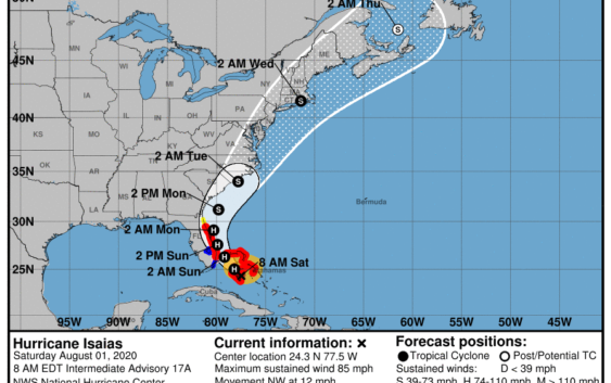
8 a.m. update
As of 8 a.m. Saturday, Hurricane Isaias was churning in the Caribbean and bringing heavy rain and winds to the Bahamas.
The storm was moving northwest at about 12 mph, but some decrease in forward speed is expected, according to the latest update from the National Hurricane Center.
A turn toward the north-northwest is expected by late Sunday. Isaias will likely approach the Florida peninsula Saturday night through Sunday.
Maximum sustained winds were recorded near 85 mph with higher gusts. The hurricane center predicts little change in strength through Sunday.
Hurricane-force winds extend outward up to 35 miles from the center and tropical-storm-force winds extend outward up to 175 miles.
Coastal North Carolina is likely to experience heavy surf and rip currents through the weekend. Tropical storm force winds could reach the area by late Sunday into early Monday morning.
The next update from the National Hurricane Center will be at 11 a.m. Saturday.
*****Editor’s Note: Our emergency coverage on Hurricane Isaias is being provided free as a public service to our readers. Please support local journalism by subscribing:
Wilmington StarNews: www.StarNewsOnline.com/subscribenow
New Bern Sun Journal: www.newbernsj.com/subscribenow
Jacksonville Daily News: www.jdnews.com/subscribenow
Kinston Free Press: www.kinston.com/subscribenow