- Hurricane survival kit: How to keep your family safe when a hurricane hits
- Houston-area storm damage: Update on status of schools, power outages and resources for storm victims
- EF-1 tornadoes ripped through Cypress, Waller County areas with winds at more than 100 mph, NWS reports
- Houston-area storm damage updates: Clean up continues after NWS says two EF-1 tornadoes and powerful derecho ripped through SE Texas
- Low risk of damaging winds, hail from Saturday storms
TRACKING ISAIAS: Hurricane warning issued for Cape Fear coast
Hurricane conditions expected in Southeastern North Carolina Monday night
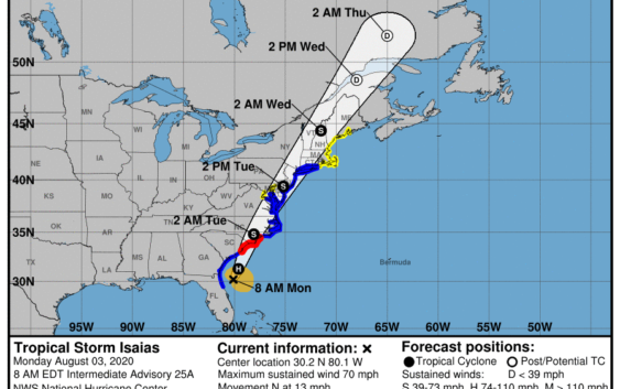
As of 8 a.m. Monday, Tropical Storm Isaias was located about 100 east-southeast of Jacksonville, Florida, and about 250 miles south-southwest of Myrtle Beach, South Carolina.
The storm was moving at 13 mph and other rain bands were already moving into the Cape Fear region. Rain and thunderstorms were reported throughout Brunswick, New Hanover and Pender counties.
Maximum sustained winds were at 70 mph, but some strengthening is possible before the center approaches the North Carolina coast late Monday night.
Tropical storm-force winds extend outward up to 125 miles from the center. During the past hour, a wind gust to 40 mph was observed at the St. Augustine Pier, Florida, and a sustained wind of 34 mph and a gust to 40 mph were measured by a Weatherflow station at the Jacksonville Beach Pier, Florida.
The next update from the National Hurricane Center is expected at 11 a.m.
*****Editor’s Note: Our emergency coverage on Hurricane Isaias is being provided free as a public service to our readers. Please support local journalism by subscribing:
Wilmington StarNews: www.StarNewsOnline.com/subscribenow
5 a.m. Update
A hurricane warning has been issued from South Santee River, South Carolina, to Surf City. A tropical storm warning extends northward from Surf City to Rhode Island.
Although Isaias was still a tropical storm as of 5 a.m., some strengthening is possible Monday — prompting the hurricane warning for the Cape Fear coast.
A hurricane warning means that hurricane conditions are expected somewhere within the warning area within 24 hours. A tropical storm warning means tropical storm conditions are likely within 36 hours.
Around 6:30 a.m. Monday, early rain bands from Isaias were moving into Brunswick County. Conditions are expected to deteriorate throughout the day Monday with the center of Isaias approaching the Cape Fear coast late Monday.
Isaias is moving toward the north near 9 mph. A turn toward the north and north-northeast along with an increase in forward speed is expected later Monday and Tuesday. The center of Isaias will pass well east of the Georgia coast through Monday morning. The center of Isaias will then approach the coast of northeastern South Carolina and southern North Carolina within the hurricane warning area later Monday. The center will then move inland over eastern North Carolina Monday night and move along the coast of the mid-Atlantic states on Tuesday and into the northeastern United States by Tuesday night.
Maximum sustained winds are near 70 mph with higher gusts. Some strengthening is anticipated Monday, and Isaias is forecast to regain hurricane strength before it reaches the North Carolina coast.
The next update from the National Hurricane Center is expected at 8 a.m.