- WATCH: Video Shows Confirmed Tornado touches down in Columbus County
- Residents begin clean up after storms, apparent tornado roll through NC Tuesday
- NC State researchers find increased fecal contamination in coastal waters due to sunny day flooding
- Flooding lingers in Liberty County neighborhoods near Trinity River with more rainfall expected
- North Carolina behind on hurricane preparedness, study shows
Tropical Storm Zeta becomes 27th named storm of season, could bring moisture to North Carolina later this week
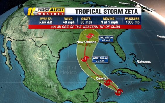
Tropical Storm Zeta formed overnight, becoming the 27th named storm of this hurricane season.
The track currently has Zeta moving into the Gulf. The system will weaken as it migrates into the region but is still expected to produce rounds of potentially heavy rain through Thursday. It will either hit as a weak hurricane or a strong tropical storm.
ABC11 First Alert Meteorologist Steve Stewart said Zeta’s formation now ties a 2005 record for 27 named storms.
Record tying named storms with Tropical Storm Zeta. The record was back in 2005 with 27 named storms. Zeta’s moisture could make it to the Carolinas as by Thursday. pic.twitter.com/QXV7sZETOW
— Steve Stewart (@StewartABC11) October 25, 2020
Zeta currently has maximum sustained winds of 40 mph and is tracking north at 1 mph. The storm is forecast to approach the northern Gulf Coast as a tropical storm Tuesday night and Wednesday, potentially bringing storm surge, rainfall and winds impacts to Louisiana and the Florida Panhandle.
Moisture from Zeta could make it into the Carolinas by Thursday.
The system will pass to the northeast and through the mid-Atlantic overnight Thursday, drying out for most of the Triangle by Friday.
Copyright © 2020 WTVD-TV. All Rights Reserved.