- Flooding lingers in Liberty County neighborhoods near Trinity River with more rainfall expected
- North Carolina behind on hurricane preparedness, study shows
- North Carolina way behind on hurricane preparedness, study shows
- New hurricane preparedness report doesn't rank North Carolina well
- New hurricane preparedness report doesn't rank North Carolina well
Widespread downpours continue in Houston area with possibility of severe weather | View forecast
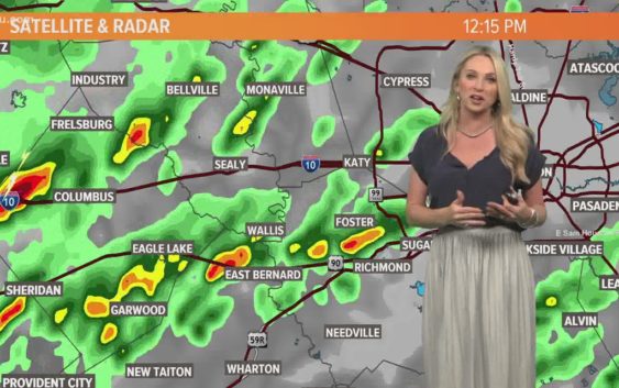
Watch the latest forecast and radar here as storms push through the Houston area.
HOUSTON — The KHOU 11 Weather team is tracking a “marginal” risk of severe weather across Houston and the rest of Southeast Texas as storms and rain push through Friday and Saturday.
As of 7 a.m. the first of the storms were already sparking up on the west side and north of town, but even as this first round clears, more is on the way for this afternoon. The poor weather will continue this afternoon and all of tomorrow as well — with some very chilly temps lined up for next week.
Here’s what to expect.
Cold fronts pushing through:
The cool front that came through on Wednesday is now hanging out along the coast and will back up as a warm front tonight into Friday. When it does, it’ll bring with it abundant moisture and a warm, unstable atmosphere. That will be the main ingredients for our heavy rain event. As our Canadian cold front moves in, it’ll begin ringing out the abundant moisture in place in the form of heavy showers and thunderstorms.
Marginal risk of severe weather:
On Friday, the Storm Prediction Center does have us in a ‘marginal’ risk of severe weather (1 out of 5) for the small risk of small hail and some gusty winds. Tornadoes are not expected.
By Saturday, an area of low pressure rides up along the front that moved in Friday evening and Saturday morning and will once again activate the heavy rain over our region. However, given the much cooler weather in place, this appears to be more of just a heavy rain event instead of a mix of rain and strong thunderstorms.
So to recap, Friday is a day of rain mixed with some stronger storms (lightning, thunder, small hail, gusty winds) while Saturday will be just heavy rain with the absence of anything other than a rumble of thunder.
The amount of rain we are expecting both Friday and Saturday should total two to four inches with isolated areas getting as much as five inches.
Given that most of the vegetation has gone dormant and the ground is extremely dry, we could see excessive runoff which could cause some minor flash flooding in the usual, suspect spots. However, we are not expecting widespread flooding at this time.
Track the storms: Houston interactive weather map
When the rain will clear and when chilly temps arrive
By very early Sunday, the entire system begins to exit to the east and behind it, high pressure will build in which will set the stage for significantly colder temperatures by Monday. We’re talking highs in the low 50s and lows close to freezing by Tuesday morning.
If you live outside the core of the metro (generally north of 1960 and west of Highway 6), be thinking about covering your plants. A widespread freeze is expected and a Freeze Warning may be issued as early as Monday.