- The deadliest tornadoes to ever hit Austin
- Whiteville resident recalls events from Tuesday nights tornado
- Tornado damage reported in southern NC after Tuesday's severe storms
- If your home floods, here are steps you can take to address mold
- WATCH: Video Shows Confirmed Tornado touches down in Columbus County
Weekend brings level 1 chance of severe weather
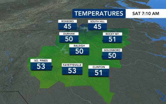
Saturday morning brought patchy fog and potential for a few showers. A small band of rain will swing through some of our southern counties through 9 a.m.
Afterwards, Saturday will clear up into a pleasant afternoon with some sunshine and highs in the mid-60s.
However, Sunday sees some parts of the state under a level one risk for severe weather, including wind damage and isolated tornadoes. Sunday morning starts clear, but brings an increasing chance for heavy rain and overnight storms into Monday morning.
On Monday, a cold front passing over the area keeps us under a level one risk for severe weather, making for a messy morning commute.
Track rain with the DualDoppler5000
“It’s going to be a messy start to the work week,” she said.
By Tuesday, sunshine will return, but it will feel like winter.
The daytime high is only forecast to reach the low 50s in Raleigh. It will be much cooler in western North Carolina, and the mountains could even see some snow.
Tuesday, Wednesday and Thursday will all be chilly days in the Triangle, and overnight temperatures will drop into the upper 20s to low 30s, making it feel like winter again for the WRAL Tower Lighting on Dec. 1.
