- WATCH: Video Shows Confirmed Tornado touches down in Columbus County
- Residents begin clean up after storms, apparent tornado roll through NC Tuesday
- Flooding lingers in Liberty County neighborhoods near Trinity River with more rainfall expected
- North Carolina behind on hurricane preparedness, study shows
- North Carolina way behind on hurricane preparedness, study shows
Flash flood warning in effect for Orange, Durham counties as rain continues to pour
Raleigh, N.C. — Rain, rain and more rain.
A flash flood warning was issued for parts of the Triangle, including Durham and Orange Counties Thursday afternoon as the torrential rain swept across central North Carolina. Downed power lines on Millbrook Road in Raleigh were one example of the damage the storms are leaving in their wake.
As we get into the afternoon Thursday, storms are expected to get heavier. The rain is expected to continue overnight, WRAL meteorologist Kat Campbell said.
“Some of this rainfall is coming down very, very quickly,” Campbell said.
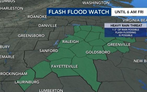
Thursday morning, a flash flood watch was issued for Wake County and points north, south and east. The watch is in effect until Friday at 6 a.m. The threat includes anywhere from 1 to 3 inches of rain and the possibility of flash flooding. The flash flood watch is also in effect for most of the WRAL viewing area.
Areas near Goldsboro, Fayetteville and Greenville are expected to see the most rain. Residents in these areas should watch out for flooding.

Storms on Thursday carry a Level 1 risk for severe weather in central North Carolina. Damaging wind gusts and heavy rain are the primary threats.
WRAL meteorologist Mike Maze said scattered thunderstorms are expected to be “quite numerous on Thursday.” It’s a good sign in terms of fighting the drought we’ve seen for much of the last three months.
“[This is] the best rain chances we’ve seen in quite some time,” said Maze.
Some parts of the area got drenched on Wednesday, making flooding possible today. Parts of the area had more than four inches of rain over a 24-hour span. RDU logged about 2.24 inches, more than it saw the entire month of May.
Tornado
On Wednesday afternoon, a tornado was confirmed in Duplin County near Wallace. Storms were heavy, with strong winds, from Wallace on up to Kinston.
The tornado caused a shed to blow over, WITN reported.
Dozens of counties, including Wake, Durham and Harnett, were under a flood advisory on Wednesday.
Forecast for the rest of the week
We’ll see warm days with highs in the 80s bring the chance for thunderstorms on Thursday and Friday afternoon, with the possibility of some relief from recent drought conditions. We’ll get waves of rain starting around noon and all through the evening commute.

The rain is a good sign considering we just completed the driest spring on record at RDU with just over five inches of rain in a three-month span.
Thursday carries a Level 1 risk for severe weather in central North Carolina. Damaging wind gusts and heavy rain are the primary threats.
By Friday, the rain chances drop to 50 percent, with even less chance for rain through the coming weekend.
Maze said according to the Weather Prediction Center, over the next 7 days, central North Carolina could see “a fairly decent amount of rain,” with some locations getting an an inch or two.

“We are coming off the driest spring on record for Raleigh, so the increasing rain chances are great to see,” he added.