- WATCH: Video Shows Confirmed Tornado touches down in Columbus County
- Residents begin clean up after storms, apparent tornado roll through NC Tuesday
- NC State researchers find increased fecal contamination in coastal waters due to sunny day flooding
- Flooding lingers in Liberty County neighborhoods near Trinity River with more rainfall expected
- North Carolina behind on hurricane preparedness, study shows
Watch Live | Latest Tropical Storm Elsa projected path, models, and potential impact to First Coast
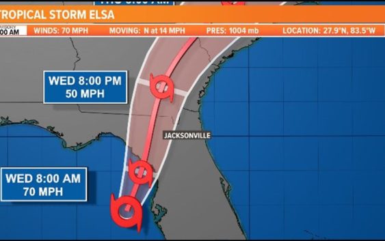
The biggest impact to monitor will be heavy rainfall and stronger gusts to 50 mph in severe storms. There is also a threat for isolated tornadoes.
JACKSONVILLE, Fla. — As of 2 a.m. Wednesday: Elsa has weakened to a tropical storm. However, our forecast and impacts for the First Coast are unchanged. The storm is located 60 miles west of Tampa.
The First Coast will feel its impacts from Elsa starting Wednesday morning and through the evening. The biggest impact to monitor will be heavy rainfall and 60 mph gusts in severe storms. There is also a threat for isolated tornadoes since the Jacksonville area is forecast to be on the eastern side of Elsa’s center as it treks north-northeast. The ground is already very saturated with recent, prolonged wet weather. It won’t take much wind to cause tree damage.
The worst of the weather will be passing the First Coast starting Wednesday morning through evening with conditions improving by Wednesday night, but isolated storm chances will continue Thursday with the west flow.
The following are some flood-prone areas due to rain, not storm surge
FIRST COAST IMPACTS:
- Rounds of heavy rainfall will continue through Wednesday evening, which could aggravate ongoing river and creek flooding and enhance the potential for localized flash and urban/small stream flooding.
- There is a potential for tropical-storm-force winds (mainly inland) with damaging wind gusts of 60 mph in severe storms, which could lead to fallen trees or tree limbs and power outages late Tuesday and Wednesday.
- Any wobbles in the storm’s track could affect the extent of these impacts, so continue to check-in for updates.
Elsa is also the earliest-known fifth named storm on record for the Atlantic basin in the satellite era (1966-present), breaking the record formerly held by Edouard on July 6, 2020.
It should be noted that the average NHC track errors are 175 miles and 200 miles on days 4 and 5, respectively. Given the larger-than-normal uncertainty and because hazards will extend well away from the center of the storm, everyone is urged to not focus on the exact forecast points.
NHC KEY MESSAGES:
1. As Elsa moves across the western Florida Peninsula through Wednesday, heavy rainfall may result in an isolated flash, urban, and minor river flooding, with considerable flash and urban flooding possible in the southwest and western portions of Florida. Mid to late week, heavy rainfall across coastal Georgia, South Carolina, North Carolina, and southeastern Virginia may result in isolated flash and urban flooding, with considerable flash and urban flooding possible across coastal Georgia and the Lowcountry of South Carolina.
2. There is a danger of life-threatening storm surge along portions of the west coast of Florida tonight and Wednesday, and a Storm Surge Warning is in effect for that area.
3. A Hurricane Warning has been issued for a portion of the west-central and Big Bend coast of Florida, where hurricane conditions are possible Wednesday. Tropical storm conditions are expected across portions of the Florida Keys and much of the west coast of the state, where a Tropical Storm Warning is in effect.
4. A Tropical Storm Watch has been issued for the Georgia coast and portions of the South Carolina coast, where tropical storm conditions are possible late Wednesday and early Thursday.
Hurricane season is already here and it’s time to be prepared if you aren’t already. Make sure you have had conversations with your loved ones about what you would do if a storm were to threaten.
This year, NOAA released the new seasonal averages for the Atlantic basin. According to the 30-year data from 1991 to 2020, the new averages include 14 named storms, 7 hurricanes, and 3 major hurricanes. The previous Atlantic storm averages, based on the period from 1981 to 2010, were 12 named storms, 6 hurricanes, and 3 major hurricanes. The averages from 1951-1980 , were 11 named storms, 5 hurricanes, and 1 major.
Hurricane safety and preparedness are critically important before the season begins on June 1. NOAA’s National Weather Service provides resources to prepare for hurricane hazards and real-time updates about active weather systems from the National Hurricane Center at www.hurricanes.gov.
The Atlantic hurricane season officially runs from June 1 to November 30.
Download the First Coast News app and sign up for severe weather alerts