- Early voting for May 28 primary runoff elections will go on, despite storm damage
- Hurricane survival kit: How to keep your family safe when a hurricane hits
- Houston-area storm damage: Update on status of schools, power outages and resources for storm victims
- EF-1 tornadoes ripped through Cypress, Waller County areas with winds at more than 100 mph, NWS reports
- Houston-area storm damage updates: Clean up continues after NWS says two EF-1 tornadoes and powerful derecho ripped through SE Texas
Heat advisory issued, Level 1 threat for severe weather in effect through the evening
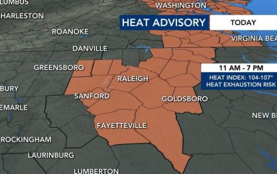
Raleigh, N.C. — Stay hydrated — the heat index cold climb as high as 107 degrees on Wednesday.
Wednesday and Thursday will both feature heat indices between 105-107 degrees.
A heat advisory has been issued for Wednesday in Wake, Durham, Chatham, Cumberland, Edgecombe, Franklin, Halifax, Harnett, Johnston, Lee, Nash, Orange, Sampson, Wayne and Wilson counties. The advisory begins at 11 a.m. and is over at 7 p.m.
On top of that, the northern part of the WRAL viewing area is now under a Level 1 risk for severe weather. The risk area covers part of Wake County and all of Durham and Orange counties.

Damaging wind gusts, heavy downpours and lightning strikes are all possible in the afternoon and evening hours on Wednesday.
Hot temperatures and high humidity may cause people to experience heat-related illness.
Officials say to prevent heat exhaustion, you should:
- Drink plenty of water
- Stay in air conditioned areas
- Stay out of the sun
- Don’t leave young children or pets inside hot cars
- Wear loose-fitting clothes
- Reduce outdoor work as much as possible
Wake County will open cooling stations Wednesday through Friday, offering shelter between 11 a.m. and 5:15 p.m. at:
- Wake County Human Services, 220 Swinburne St., Raleigh
- Eastern Regional Center, 1002 Dogwood Drive, Zebulon
- Northern Regional Center, 350 E. Holding Ave., Wake Forest
- Southern Regional Center, 130 N. Judd Parkway NE, Fuquay-Varina
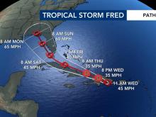
Meteorologists are also tracking Tropical Storm Fred, which formed near Puerto Rico on Tuesday. Fred could impact Florida’s western coast by the weekend and bring rain to North Carolina next week.