- $40 million to go to underserved SC counties for Hurricane Helene recovery. Here's what you need to know.
- Family honors Air Force veteran Derwin Anderson Jr. after he died in June flash floods
- City of Wilmington addresses flooding on New Centre Drive
- Harnett County fire: Two homes damaged
- Medical examiner identifies 13th victim from massive flash flood in San Antonio
Tropical Storm Ida gains strength in the Caribbean, expected to become a hurricane today
Tropical Storm Ida is expected to make landfall along Louisiana’s Gulf Coast Sunday, possibly as a Category 3 major hurricane.
CHARLOTTE, N.C. — The historic peak of hurricane season is September 10, but it is late August and September that some of the more notable storms have formed and even impacted the Carolinas.
As of August 27, there are two active tropical disturbances and one tropical storm in the Atlantic and Caribbean. The main threat, however, is Tropical Storm Ida which will likely become a hurricane today.
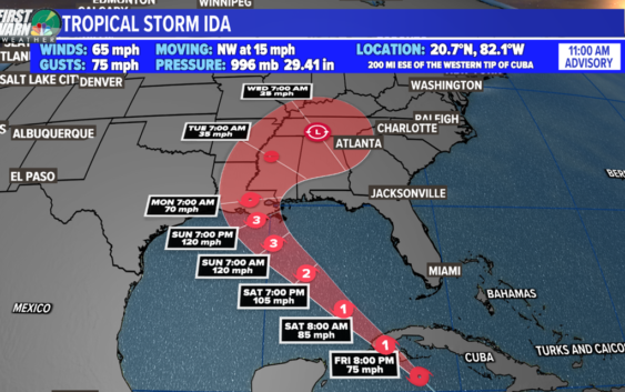
Tropical Storm Ida
Location: 200 miles east-southeast of western Cuba
Potential Impacts: Isle of Youth, western Cuba, United States northern Gulf coast
As of 11 a.m. Friday, Tropical Storm Ida was moving northwest in the Caribbean toward the western tip of Cuba. The storm is about 75 miles southeast of The Isle of Youth with maximum sustained winds of 65 mph.
Tropical Storm Ida will pass near western Cuba today and tonight. Due to minimal time over land, the terrain will not be enough to weaken Ida substantially. This weekend, the storm will emerge into the southeastern and central Gulf of Mexico. Then, it is forecast to approach the U.S. northern Gulf Coast on Sunday.
The latest track from the National Hurricane Center suggests a Category 3 major hurricane will make landfall along the Louisiana coast by Sunday afternoon. The intensity forecast is still subject to change due to the potential for rapid intensification. This is defined as a wind increase of 35 mph within a 24-hour period.
Wave Number 1: Invest 97-L
Location: 600 miles east of Bermuda (central Atlantic)
Development Chance: 60% within the next five days
Potential Impacts: Mid-Atlantic Ocean
Development potential has lowered slightly for Invest 97-L over the past 24 hours. Conditions are marginally favorable for development late this week and this weekend, so a tropical depression could form as it drifts slowly eastward.
This system is no concern to the United States.
Wave Number 2: Invest 98-L
Location: South-central Atlantic
Development Chance: 80% within the next five days
Potential Impacts: Atlantic Ocean
An area of disorganized showers and thunderstorms continues to churn in the eastern Atlantic Ocean. Moderate development is possible within the next few days, however, unfavorable conditions are expected this weekend.
This disturbance has the best chance to become our next named storm, which is Julian.