- Rock Hill storm damage costs are 'somewhere around $5 million.' That number doesn't include damage to personal property
- Rock Hill storm damage costs are 'somewhere around $5 million.' That number doesn't include damage to personal property
- ‘Somewhere around $5 million’ | Rock Hill officials see major storm damage costs
- The deadliest tornadoes to ever hit Austin
- Whiteville resident recalls events from Tuesday nights tornado
Charlotte: Severe Weather or Not? Thursday's Forecast
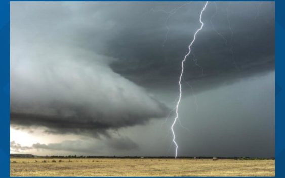
There is a chance for severe storms in the Carolinas on the last day of March (Thursday) but the timing of the front is key for severe weather or not.
CHARLOTTE, N.C. —
Another Week of Spring; Another Storm System:
This storm system is the big story for the South Wednesday as widespread thunderstorms and even tornadoes are forecasted around Mississippi and surrounding states. This system is massive, dumping snow for areas in the northern Midwest (Minnesota and Wisconsin especially) and the cold front extends all the way down into the Gulf of Mexico. This storm system will be the strongest on Wednesday and will get weaker closer to the Carolinas but still comes with a low to medium threat for severe thunderstorms.
The Carolina’s Severe Threat Thursday:
The reason why there are two separate orange areas (medium threat for severe storms) to the north and south of Charlotte is because the ingredients are better there than the Greater Charlotte area.
- South: This area has more moisture present that will lead to better storm fuel and make thunderstorms more numerous
- North: This area is under the lead shortwave that has more shear involved. This will increase thunderstorm development and even the chance for tornadoes
The Timing Helps:
Storms arriving in the morning have the best chance to be less severe than ones that arrive in the afternoon. The coolest temperature of the day (most of the time) is hit right around sunrise. The cooler it is, the less storm fuel is present for thunderstorms.
Right now, Charlotte is set to see most of the the rain and storms with this system from mid morning into the early afternoon.
As you can see, from the most recent updated Futurecast, storms become widespread through the morning and will start to intensify as they work east. All of the charlotte area has a shot at seeing thunderstorms to start the day.
Current Charlotte Storm Window: 8 a.m. to 2 p.m.
Even though conditions are not as unstable as later on in the day, there is still a chance for some strong to severe thunderstorms that could produce some damaging wind gusts and produce frequent lightning.
Severe Threats:
Storms are more likely to become severe east of I-77 through the morning into the afternoon, but this system is quite strong, which means any time mid morning and beyond, the stage is set for thunderstorms.
Wind: The number one threat would be for severe thunderstorms with gusty winds. These winds could occasionally gust over 50-60 mph, causing spotty damage and downed trees.
Tornado: There will be some spin to the atmosphere and there is a chance for a spin-up tornado but the treats are very low at this time. The Storm Prediction Center has a 2% chance for tornadoes in the areas north and south we mentioned previously in the article (in orange).
Hail: Currently this threat is the lowest severe parameter for the area.
Flooding: Any thunderstorm system has a chance to bring some localized and urban flooding, so the threat is there but most rain totals will range from 0.5-1.5″. This will all come within a 6 hour period which will lead to some significant ponding in area. Would not be unheard of to see some isolated reports of over two inches of rain (especially in the Mountains).
A Windy Day Regardless:
Due to a strong low-level jet, there will be wind gusts up to 30-40+ mph across the area, as the front is rolling through. Winds will be the highest as the rain and storms are entering and leaving the Charlotte area. It is a type of day you will see the clouds flying across the skies as this system is racing east.