- WATCH: Video Shows Confirmed Tornado touches down in Columbus County
- Residents begin clean up after storms, apparent tornado roll through NC Tuesday
- NC State researchers find increased fecal contamination in coastal waters due to sunny day flooding
- Flooding lingers in Liberty County neighborhoods near Trinity River with more rainfall expected
- North Carolina behind on hurricane preparedness, study shows
Severe weather possible in Charlotte Thursday
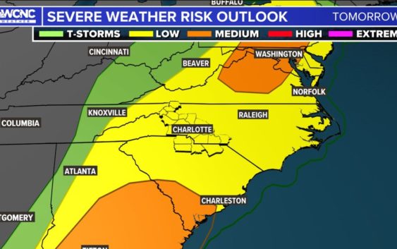
There is a chance for severe storms in the Carolinas on Thursday, but a few factors could play into how strong the storms are.
CHARLOTTE, N.C. — A storm system moving across the South will bring widespread rain and storms to the Carolinas Thursday with a chance for more severe weather in the Charlotte area.
This system is massive and is having an impact from Minnesota and Wisconsin with heavy snow to severe weather in the Southeast along the Gulf Coast. Widespread storms and tornadoes are in the forecast in Mississippi and surrounding states as the system moves east.
Luckily for the Carolinas, the storm system will be at its strongest Wednesday and will weaken as it gets closer to us. But there is still a low-to-medium threat of severe thunderstorms.
Severe weather threat Thursday
The reason why there are two separate orange areas (medium threat for severe storms) to the north and south of Charlotte is because the ingredients are better there than in the greater Charlotte area.
- South: This area has more moisture present that will lead to better storm fuel and make thunderstorms more numerous
- North: This area is under the lead shortwave that has more shear involved. This will increase thunderstorm development and even the chance for tornadoes
The timing helps
Storms arriving in the morning have the best chance to be less severe than ones that arrive in the afternoon. The coolest temperature of the day (most of the time) is right around sunrise. The cooler it is, the less storm fuel is present for thunderstorms.
Right now, Charlotte is set to see most of the rain and storms with this system from mid-morning into the early afternoon.
As you can see, from the most recent updated futurecast, storms become widespread through the morning and will start to intensify as they work east. All of the Charlotte area has a shot at seeing thunderstorms to start the day.
Current Charlotte storm window: 8 a.m. to 2 p.m.
Even though conditions are not as unstable as later on in the day, there is still a chance for some strong to severe thunderstorms that could produce some damaging wind gusts and produce frequent lightning.
Severe threats
Storms are more likely to become severe east of Interstate 77 through the morning into the afternoon, but this system is quite strong, which means any time mid-morning and beyond, the stage is set for thunderstorms.
Wind: The No. 1 threat would be for severe thunderstorms with gusty winds. These winds could occasionally gust over 50-60 mph, causing spotty damage and downed trees.
Tornado: There will be some spin to the atmosphere and there is a chance for a spin-up tornado but the treats are very low at this time. The Storm Prediction Center has a 2% chance for tornadoes in the areas north and south we mentioned previously in the article (in orange).
Hail: Currently this threat is the lowest severe parameter for the area.
Flooding: Any thunderstorm system has a chance to bring some localized and urban flooding, so the threat is there but most rain totals will range from a half-inch to 1.5 inches. This will all come within a six-hour period, which will lead to some significant ponding in areas. It wouldn’t be unheard of to see some isolated reports of 2 inches of rain, especially in the North Carolina mountains.
A windy day regardless
Due to a strong low-level jet, there will be wind gusts up to 30-40+ mph across the area, as the front is rolling through. Winds will be the highest as the rain and storms are entering and leaving the Charlotte area. It is a type of day you will see the clouds flying across the skies as this system is racing east.