- Tornado Watch for Coastal Plains Sunday evening
- Two people, including a child, dead after Oklahoma tornadoes; governor declares state of emergency
- Build your hurricane season preparedness kits this tax-free weekend
- Residents begin going through the rubble after tornadoes hammer parts of Nebraska and Iowa
- Midwest tornadoes flatten homes in Nebraska suburbs and leave trails of damage in Iowa
National Hurricane Center: Fiona becomes category 3 hurricane, may bring elevated rip currents to NC

6 minutes ago
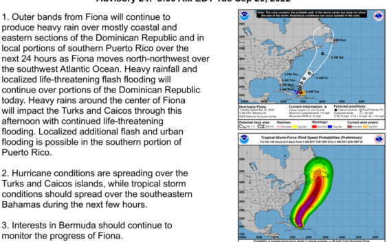
RALEIGH, N.C. (WTVD) — Fiona is now a category 3 hurricane, according to the National Hurricane Center. That could bring rough seas and elevated rip currents to the North Carolina coast.
The eye of the hurricane made landfall along the coast of Dominican Republic near Boca de Yuma at 3:30 a.m. local time as a category 1, but as of the 2 a.m. update has surged into a category 3.
The center will move over the eastern portions of Dominican Republic Tuesday morning and come out over the southwestern Atlantic Tuesday afternoon. The center is forecast to pass near or to the east of Turks and Caicos.
While Fiona won’t produce any direct impacts to the Carolinas, it’s possible that a late-week cold front misses the slow-moving system, keeping it lingering offshore into the weekend. This could result in rough seas and perhaps an elevated rip current risk late this week and into the weekend. However the upcoming high pressure should be strong enough to keep this system well away from land.
Elsewhere in the Tropics, disorganized showers and thunderstorms over the central subtropical Atlantic are associated with a poorly defined area of low pressure. Some slow development is possible during the next couple of days before conditions weaken later this week. The system should generally move northward or northeastward while remaining over the open central subtropical Atlantic.
Copyright © 2022 WTVD-TV. All Rights Reserved.
Related Topics