- 'This is our life' | Sulphur, Oklahoma family reacts to losing everything in Saturday's deadly tornadoes
- Severe weather threat dwindles Sunday night
- Tornado Watch for Coastal Plains Sunday evening
- Four people, including an infant, dead after Oklahoma tornadoes; governor declares state of emergency
- Two people, including a child, dead after Oklahoma tornadoes; governor declares state of emergency
Cat. 3 Hurricane Ian hits Cuba; 2nd landfall expected in Florida before heavy rain in NC
RALEIGH, N.C. — Central and eastern North Carolina are bracing for possibly detrimental impacts from Hurricane Ian late this week.
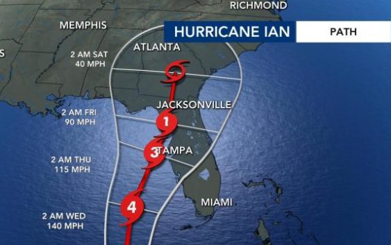
Hurricane Ian on Tuesday made landfall in Cuba as a major Category 3 storm. Ian is expected to make a second landfall in Florida by Thursday morning. After that, it will weaken and bring heavy rain to N.C.
Hurricane Ian impacts, timing for NC
Rain will likely begin late Friday in our area, but we’ll feel the biggest impacts Saturday.
“We’re dry Friday morning, then very slowly during the day, we start to see that rain shifting northward,” WRAL meteorologist Elizabeth Gardner explained. “So by Friday afternoon there’s some heavy rain in our southern counties. That rain continues to lift up across our area and we’re just going to see waves between Friday afternoon and during the day Saturday.”

Gardner said Saturday is going to be “almost an all-day rain,” and showers will continue Sunday.
“It’s definitely looking like a wet weekend for us,” Gardner said. “It’s also going to be windy. Our maximum wind gusts as we get into Thursday, Friday and Saturday are likely to be anywhere from 25 to 35 mph.”

The Triangle and communities to the east could experience pockets of heavy rain, with up to 4 inches possible, gusty winds and isolated tornadoes all during day on Saturday with rain lingering into Sunday.
There will be wind and rain in the mountains, but the weather won’t be severe there, Gardner said. Ian’s remnants could be moving into the N.C. mountains by late Saturday night into early Sunday.

Ian hits Cuba, landfall expected in Florida
Ian on Tuesday was upgraded to a major hurricane at 4:45 a.m. with winds at 115 mph. Cuba was already experiencing heavy rain as Ian made landfall along the western coast, and high storm surge and wind damage will also create dangerous conditions.
Ian will strengthen into a Category 4 storm on Wednesday before weakening due to drier air. A second landfall is expected for Florida near Tampa late Wednesday or Thursday morning, possibility as a Category 2 or 3 storm.

“This is not great news for Tampa,” WRAL meteorologist Elizabeth Gardner said. “A couple of days ago, it looked like the storm would probably make landfall somewhere on the west coast of Florida as a Category 1. [Now] it looks like early in the morning on Thursday with 120 mph winds. So not only is there going to be huge storm surge and a lot of heavy rain, but also very strong winds.”

According to Gardner, storm surge in Florida could be 5 to 10 feet, especially around Tampa Bay. Between 8 and 10 inches of rain will be likely with isolated pockets of up to 15 inches of rain possible.
Hurricane Ian will weaken into a tropical depression as it moves along Florida’s coast into Georgia, and N.C. could feel impacts as soon as Friday.
Monday, Sept. 26
Hardware stores across the Triangle were fully stocked ahead of Hurricane Ian. Some of the most popular items that go quickly when any storms threaten include batteries, flashlights and extension cords.
Officials in Raleigh are keeping a cautious eye on Hurricane Ian as it charges toward Cuba and Florida.
Stormwater crews were ramping up efforts Monday to reduce the impacts of Hurricane Ian throughout the city. They started lowering lake levels at Lake Johnson in anticipation of heavy rainfall.
Crews told WRAL News if they don’t control water levels at Lake Johnson, all that water rushes downstream and hits flood-prone areas like Rose Lane.
Heavy rain and whipping winds from major storms have resulted in fierce flooding in parts of the city like Rose Lane where Walnut Creek flows through.
“What we’re trying to do is lower the lake levels to try to capture as much rainfall runoff as we can to try to help prevent flooding downstream,” said Kelly Daniel, the flood early warning system project manager for the city of Raleigh.
Daniel said it’s a proactive measure to keep residents in those flood-prone areas safe.
Officials said if you are in the vicinity of flood plains keep an eye on the forecasts and never drive through a flooded area.
Duke Energy ready to respond to power outages
Another area of concern with any possible weather event is power outages.
Duke Energy said that before it sends crews to help Florida, is has to make sure there are enough crews to help North Carolina in case the situation worsens. Duke Energy said it expects to have a better idea of storm impacts in North Carolina over the next few days.
Meanwhile, the Red Cross is often among the first to respond after storms roll through an area.
“We have two concerns: supporting our team on tour in the north Florida gulf coast area where the storm may indeed impact. So we prepare and send some qualified individuals there,” said Barry Porter with the American Red Cross, Eastern NC Region. “At the same time, we’re doing hold-downs and evaluating where our own people are so if something does happen in the Carolinas we can also respond.”
Porter said the most important thing is to find and seek safe shelter, have a supply kit ready to go and to be weather weary after the event.