- 'This is our life' | Sulphur, Oklahoma family reacts to losing everything in Saturday's deadly tornadoes
- Severe weather threat dwindles Sunday night
- Tornado Watch for Coastal Plains Sunday evening
- Four people, including an infant, dead after Oklahoma tornadoes; governor declares state of emergency
- Two people, including a child, dead after Oklahoma tornadoes; governor declares state of emergency
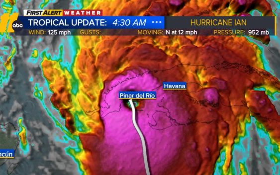
Hurricane Ian updates: Storm hits Cuba as Category 3, NC winds pick up on Wednesday
RALEIGH, N.C. (WTVD) — Hurricane Ian is moving over Cuba as a Category 3 storm with projections showing it hit Florida’s west coast as a major hurricane as early as Wednesday.
Ian hit the western tip of Cuba as a major hurricane with top wind gusts of 155 mph over warm Gulf of Mexico waters before striking Florida.
On Tuesday morning, Ian was moving north at 12 mph with top sustained winds increasing to 125 mph. It’s projected path has moved to the south and west which could have it hit Florida sooner.
Tampa and St. Petersburg appear to be among the most likely targets for their first direct hit by a major hurricane since 1921.
“Please treat this storm seriously. It’s the real deal. This is not a drill,” Hillsborough County Emergency Management Director Timothy Dudley said at a news conference on storm preparations in Tampa.
Authorities in Cuba evacuated 50,000 people in Pinar del Rio province, sending in medical and emergency personnel, and taking steps to protect food and other crops in warehouses, according to state media.
“Cuba is expecting extreme hurricane-force winds, also life-threatening storm surge and heavy rainfall,” U.S. National Hurricane Center senior specialist Daniel Brown told The Associated Press.
The hurricane center predicted areas of Cuba’s western coast could see as much as 14 feet of storm surge Monday night or early Tuesday.
In Havana, fishermen were taking their boats out of the water along the famous Malecon, the seaside boardwalk, and city workers were unclogging storm drains ahead of the expected rain.
Havana resident Adyz Ladron, 35, said the potential for rising water from the storm worries him.
“I am very scared because my house gets completely flooded, with water up to here,” he said, pointing to his chest.
Big Weather’s hurricane emergency kit
Ian won’t linger over Cuba but will slow down over the Gulf of Mexico, growing wider and stronger, “which will have the potential to produce significant wind and storm surge impacts along the west coast of Florida,” the hurricane center said.
A surge of up to 10 feet of ocean water and 10 inches of rain was predicted across the Tampa Bay area, with as much as 15 inches in isolated areas. That’s enough water to inundate coastal communities.
As many as 300,000 people may be evacuated from low-lying areas in Hillsborough County alone, county administrator Bonnie Wise said. Some of those evacuations were beginning Monday afternoon in the most vulnerable areas, with schools and other locations opening as shelters.
“We must do everything we can to protect our residents. Time is of the essence,” Wise said.
Floridians lined up for hours in Tampa to collect bags of sand and cleared store shelves of bottled water. Gov. Ron DeSantis declared a statewide emergency and warned that Ian could lash large areas of the state, knocking out power and interrupting fuel supplies as it swirls northward off the state’s Gulf Coast.
“You have a significant storm that may end up being a Category 4 hurricane,” DeSantis said at a news conference. “That’s going to cause a huge amount of storm surge. You’re going to have flood events. You’re going to have a lot of different impacts.”
DeSantis said the state has suspended tolls around the Tampa Bay area and mobilized 5,000 Florida state national guard troops, with another 2,000 on standby in neighboring states.
RELATED: Hurricane Ian could affect already stressed supply chain
President Joe Biden also declared an emergency, authorizing the Department of Homeland Security and the Federal Emergency Management Agency to coordinate disaster relief and provide assistance to protect lives and property. The president postponed a scheduled Tuesday trip to Florida because of the storm.
Flash flooding was predicted for much of the Florida peninsula, and heavy rainfall was possible for the southeast United States later this week. With tropical storm force winds extending 115 miles from Ian’s center, watches covered the Florida Keys to Lake Okeechobee.
The hurricane center has advised Floridians to have survival plans in place and monitor updates of the storm’s evolving path.
The Associated Press contributed to this report.
Copyright © 2022 WTVD-TV. All Rights Reserved.