- Caddo Mounds State Historic Site to celebrate new visitor center, traditional grass house after 2019 tornado
- Flooding continues to wreak havoc on Southeast Texas homes
- Houston-area storm damage updates: NWS says two EF-1 tornadoes and powerful derecho event hit SE Texas
- Houston-area storm damage updates: NWS says two EF-1 tornadoes and powerful dericho event hit SE Texas
- NWS confirms two EF 1 tornados touched down Thursday -- one in the Cypress area and one in Waller County
Flooding in progress: Where rivers and streams are out of their banks and where they're close
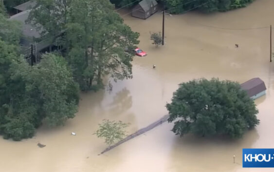
HOUSTON — We’re tracking high water all across the Houston area following days of heavy rain. And with more rain in the forecast, things are expected to get worse.
The Harris County Flood Control District is keeping tabs on rivers and streams that are out of their banks and those that are nearing it. Here is what they posted shortly after 11:30 a.m. Saturday.
You can also check the Harris County Flood Control map anytime. There are explainers on how to read it and what the different monitors mean. We have links here.
If you are in an area that’s flooded, you can get a free ride to safety. Just call 311.
FREE transportation services for evacuation are now available!
If you or someone you know requires transportation for evacuation, please contact 311 immediately. pic.twitter.com/syYCM9pKbl
— Houston OEM (@HoustonOEM) May 4, 2024